Shaizar
|
Shaizar شيزر Larissa |
|
|---|---|
| Village | |

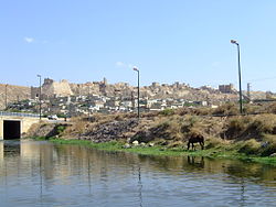
The fortress and town of Shaizar
|
|
| Location in Syria | |
| Coordinates: 35°16′04″N 36°34′00″E / 35.26778°N 36.56667°ECoordinates: 35°16′04″N 36°34′00″E / 35.26778°N 36.56667°E | |
| Country |
|
| Governorate | Hama |
| District | Mahardah |
| Subdistrict | Mahardah |
| Population (2004 census) | |
| • Total | 5,953 |
| Time zone | EET (UTC+2) |
| • Summer (DST) | EEST (UTC+3) |
Shaizar (Arabic: شيزر; also called Saijar or Larissa in Syria) is a town in northern Syria, administratively part of the Hama Governorate, located northwest of Hama. Nearby localities include, Mahardah, Tremseh, Kafr Hud, Khunayzir and Halfaya. According to the Syria Central Bureau of Statistics (CBS), Shaizar had a population of 5,953 in the 2004 census. During the Crusades, the town was a fortress in Syria, ruled by the Banu Munqidh tribe. It played an important part in the Christian and Muslim politics of the crusades.
Located on the Orontes to the northwest of Hama, Shaizar was an ancient town, known as Senzar or Sezar in the Amarna letters. To the Greeks it was known as Sidzara, but the Seleucid dynasty renamed it Larissa, after the town of the same name in Thessaly from which many colonists came.
It reverted to its earlier name under the Roman Empire and was known as Sezer under the Byzantine Empire.
Shaizar fell to the Arabs in 638 and frequently passed from Arab to Byzantine control. It was sacked in 969 by Byzantine emperor Nicephorus II, and was captured by Basil II in 999, after which it became the southern border of the Byzantine Empire and was administered by the Bishop of Shaizar.
...
Wikipedia

