September 2007 Sumatra earthquake

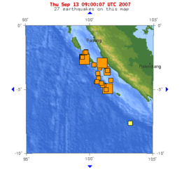
Map showing the 3 large quakes and 22 pre and aftershocks in a span of 24 hours.
|
|
| Date | 12 September 2007 |
|---|---|
| Magnitude | 8.4 Mw |
| Depth | 30 kilometres (19 mi) |
| Epicenter | 4°31′12″S 101°22′26″E / 4.520°S 101.374°E |
| Areas affected |
Indonesia Singapore Malaysia Thailand |
| Casualties | 23 killed |
The September 2007 Sumatra earthquakes were a series of megathrust earthquakes that struck the Sunda Trench off the coast of Sumatra, Indonesia, three greater than magnitude 7. A series of tsunami bulletins was issued for the area. The most powerful of the series had a magnitude of 8.4, which makes it in the top 20 of the largest earthquakes ever recorded on a seismograph.
The first earthquake occurred at 11:10:26 UTC (18:10 local time) on 12 September 2007, and was an 8.4 Mwearthquake on the moment magnitude scale. It was centered about 34 km underground, at 4°31′12″S 101°22′26″E / 4.520°S 101.374°E, about 130 km southwest of Bengkulu on the southwest coast of Sumatra, Indonesia, and some 600 km west-northwest of Indonesia's capital city, Jakarta. It was followed by several earthquakes of magnitude 5 through 6 along the same fault, west of Sumatra.
The second largest earthquake, 7.9 Mw, occurred later the same day at 23:49:04 UTC (06:49:04 local time the following day). It was centred about 10 km underground, at 2°30′22″S 100°54′22″E / 2.506°S 100.906°E, some 185 km (115 mi) south-southeast of Padang, Indonesia and about 205 km northwest of Bengkulu (about 225 km northwest of the magnitude 8.5 earthquake).
...
Wikipedia
