September 1921 San Antonio floods

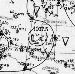
Surface weather analysis of the hurricane on September 7 after making landfall
|
|
| Date | September 7 – September 11, 1921 |
|---|---|
| Location | Mexico, Texas |
| Deaths | 215 total |
| Property damage | $19 million (1921 USD) |
In early September 1921, the remnants of a Category 1 hurricane brought damaging floods to areas of Mexico and the U.S. state of Texas, particularly in the San Antonio region. On September 4, a tropical cyclone developed in the southwestern Gulf of Mexico near the Bay of Campeche. Moving slowly in a general westward direction, the disturbance reached hurricane intensity on September 7 prior to making landfall south of Tampico, Mexico the following day. The storm weakened over land, and lost cyclonic characteristics later that day. However, a nearby high-pressure area forced the remnants of the system northward into Texas. Due to an orthographic lifting effect, the remnants were able to produce torrential and record rainfall over the state. Precipitation peaked over Central Texas, where the highest rainfall amount measured was 40 in (1,016 mm) near Thrall, Texas; this was the fourth-highest tropical cyclone-related rainfall total in Texas since record keeping began. Similarly, an observation of 36.40 in (925 mm) elsewhere in Williamson County, Texas ranked as the sixth-highest tropical cyclone-related rainfall total for the state. The high precipitation totals set nationwide records which would stand for several years.
In early September, a trough of low-pressure persisted in the southwestern Gulf of Mexico, near the Bay of Campeche. The area of disturbed weather gradually organized, and was analyzed to have become a tropical depression by 1200 UTC on September 4. In its initial stages after tropical cyclogenesis, the disturbance moved very slowly and did not intensify. Its lack of organization resulted in its estimated misplacement inland over Mexico in the Signal Corps's weather map for September 5. At the time, the storm was estimated to have a minimum barometric pressure of at least 1010 mbar (hPa; 29.83 inHg). The system remained a tropical depression until 0000 UTC on September 6, when it was estimated to have attained tropical storm intenisty. Despite the analyzed intensification, the updated Signal Corps weather maps for the tropical cyclone that day indicated that the system had degenerated back into an open trough. Continuing to intensify throughout the day, the tropical storm was estimated to have reached hurricane intensity by the following day.
...
Wikipedia
