Senlis
| Senlis | ||
|---|---|---|

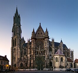
Cathedral
|
||
|
||
| Coordinates: 49°12′29″N 2°35′15″E / 49.2081°N 2.5875°ECoordinates: 49°12′29″N 2°35′15″E / 49.2081°N 2.5875°E | ||
| Country | France | |
| Region | Hauts-de-France | |
| Department | Oise | |
| Arrondissement | Senlis | |
| Canton | Senlis | |
| Intercommunality | Trois Forêts | |
| Government | ||
| • Mayor (2011–2014) | Pascale Loiseleur | |
| Area1 | 24.05 km2 (9.29 sq mi) | |
| Population (2012)2 | 15,789 | |
| • Density | 660/km2 (1,700/sq mi) | |
| Time zone | CET (UTC+1) | |
| • Summer (DST) | CEST (UTC+2) | |
| INSEE/Postal code | 60612 /60300 | |
| Elevation | 47–140 m (154–459 ft) (avg. 76 m or 249 ft) |
|
|
1 French Land Register data, which excludes lakes, ponds, glaciers > 1 km² (0.386 sq mi or 247 acres) and river estuaries. 2Population without double counting: residents of multiple communes (e.g., students and military personnel) only counted once. |
||
1 French Land Register data, which excludes lakes, ponds, glaciers > 1 km² (0.386 sq mi or 247 acres) and river estuaries.
Senlis (French pronunciation: [sɑ̃lis]) is a commune in the Oise department in northern France.
It has a long and rich heritage, having traversed centuries of history. This medieval town has welcomed some of the most renowned figures in French history, including Hugh Capet, Louis IX, the Marshal of France, Anne of Kiev and Séraphine de Senlis. The monarchs of the early French dynasties lived here, attracted by the proximity of the Chantilly forest. It is renowned for the gothic Senlis Cathedral and its vast historical monuments. Its inhabitants are called "Senlisiens" and "Senlisiennes".
Senlis is part of the province of l'Oise in the region of Hauts-de-France in the north of France. It is situated on the river Nonette, between the forests of Chantilly and d'Ermenonville in the South and d'Halatte on the North. It is located 40 kilometers from the north of Paris, 44 km from Beauvais and 79 km from Amiens. The highest point of the town (140m) lies at the heart of the forest Halatte and the lowest point is located on the banks of the Nonette, west of the city. Geologically, the area is occupied by a vast limestone plateau of the Lutetian covered mostly in silt.
...
Wikipedia


