Senafe
| Senafe | |
|---|---|
 |
|
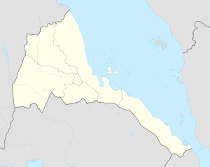
| Location in Eritrea | |
| Coordinates: 14°42′N 39°25′E / 14.700°N 39.417°E | |
| Country |
|
| Region | Debub |
| District | Senafe District |
| Elevation | 2,446 m (8,025 ft) |
| Climate | BSk |
Senafe (Tigrinya: ሰንዓፈ? Tigrinya pronunciation: [sɐnʕafɐ]) is a market town in southern Eritrea, on the edge of the Eritrean highlands. The surrounding area is inhabited by the Saho people and the Tigrinya people.
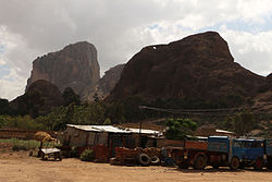
Senafe is known for the ruins of Metera (also known as Balaw Kalaw), the monolithic church of Enda-Tradqan and for the local stone outcrops.
The original name for Saanafè was Hakir. Local tradition states that the name was changed by a man named Abdullah from Sana'a in Yemen; he settled in the Awdie district of Hakir, and upon marrying a local woman he was quoted as saying "Sana-fen" which means in Arabic "where is Sana'a" he was relating to his hometown; thus the town was named Sanafe; his descendants form a tribe and are also known as Saanafè.
An early record of Sanafe is on the Egyptus Novello map, published in 1454. This map shows Sanafe at the edge of Tigray, connected to two routes, one leading west to Axum, the other south to Lake Ashangi. According to James Bruce, the party of Jesuits which included the Catholic patriarch Afonso Mendes and Fr. Jerónimo Lobo, passed through Senafe in 1625, having entered the Horn of Africa by way of Beilul and having crossed the Danikil Desert.
...
Wikipedia

