Seminole, TX
| Seminole, Texas | |
|---|---|
| City | |

The Gaines County Courthouse in Seminole.
|
|
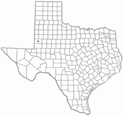
 Location of Seminole, Texas |
|
| Coordinates: 32°43′7″N 102°39′0″W / 32.71861°N 102.65000°WCoordinates: 32°43′7″N 102°39′0″W / 32.71861°N 102.65000°W | |
| Country | United States |
| State | Texas |
| County | Gaines |
| Area | |
| • Total | 3.4 sq mi (8.7 km2) |
| • Land | 3.4 sq mi (8.7 km2) |
| • Water | 0.0 sq mi (0.0 km2) |
| Elevation | 3,297 ft (1,005 m) |
| Population (2010) | |
| • Total | 6,430 |
| • Density | 1,891.18/sq mi (739.08/km2) |
| Time zone | Central (CST) (UTC-6) |
| • Summer (DST) | CDT (UTC-5) |
| ZIP code | 79360 |
| Area code(s) | 432 |
| FIPS code | 48-66764 |
| GNIS feature ID | 1346888 |
Seminole is a city in and the county seat of Gaines County in Texas, United States. The population was 6,430 at the 2010 census.
It is the birthplace of country music singers Larry Gatlin and Tanya Tucker. Paul Patterson, the Western author and educator and mentor of Elmer Kelton, was born in Gaines County.
The land for Seminole was donated by nonresident landowners to become the county seat for Gaines County. In 1906, the first move to Seminole was made by W.B. Austin and his wife Emma, who moved their general store there, which was located in Caput, Texas. During this time, several post offices found a new home in Seminole. Seminole National Bank opened its doors in 1906, followed by First State Bank in 1907. In 1912, Seminole National Bank lost over $3,000 when it was robbed. In 1914, the two banks merged to form First State Bank. In 1950, Seminole's population surpassed Seagraves, Texas, for the first time.
Seminole is located at 32°43′7″N 102°39′00″W / 32.71861°N 102.65000°W.
According to the United States Census Bureau, the city has a total area of 3.3 square miles (8.5 km2), all land.
As of the census of 2000, 5,910 people, 2,082 households, and 1,590 families resided in the city. The population density was 1,762.3 inhabitants per square mile (681.2/km²) . The 2,337 housing units had an average density of 696.9 per square mile (269.3/km²). The racial makeup of the city was 80.64% White, 1.98% African American, 0.98% Native American, 0.29% Asian, 0.02% Pacific Islander, 13.52% from other races, and 2.57% from two or more races. Hispanics or Latinos of any race were 39.59% of the population.
...
Wikipedia
