Semey
|
Semey Семей |
||
|---|---|---|
 |
||
|
||
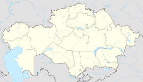
| Location in Kazakhstan | ||
| Coordinates: 50°26′0″N 80°16′0″E / 50.43333°N 80.26667°E | ||
| Country | Kazakhstan | |
| Region | East Kazakhstan Region | |
| Founded | 1718 | |
| Incorporated (city) | 1782 | |
| Government | ||
| • Akim (mayor) | Ermak Salimov | |
| Area | ||
| • Total | 210 km2 (80 sq mi) | |
| Population (2009) | ||
| • Total | 299,264 | |
| Time zone | ALMT (UTC+6) | |
| Postal code | 071400 | |
| Area code(s) | +7 7222 | |
Coordinates: 50°26′N 80°16′E / 50.433°N 80.267°E
Semey (Kazakh and Russian: Семей), until 2007 known as Semipalatinsk (Kazakh and Russian: Семипалатинск) and in 1917–1920 as Alash-kala (Kazakh: Алаш-қала, Alaş-qala), is a city in Kazakhstan, in East Kazakhstan Region, and in the Kazakhstan part of Siberia, near the border with Russia, around 1,000 kilometers (620 mi) north of Almaty, and 700 kilometers (430 mi) southeast of the Russian city of Omsk, along the Irtysh River. Population: 299,264 (2009 Census results); 269,574 (1999 Census results).
The first Russian settlement in the area dates from 1718, when Russia built a fort beside the river Irtysh, near a ruined Buddhist monastery. The monastery's seven buildings lent the fort (and later the city) the name Semipalatinsk (Russian for "Seven-Chambered City"). The fort suffered frequently from flooding caused by the snowmelt swelling the Irtysh, and in 1778 the fort was relocated 18 kilometres (11 mi) upstream to less flood-prone ground. A small city grew around the fort, largely servicing the river trade between the nomadic peoples of Central Asia and the growing Russian Empire. The construction of the Turkestan-Siberia Railway in the early 20th century added to the city's importance, making it a major point of transit between Central Asia and Siberia. On 19 May 1854 Semipalatinsk became the capital of the Semipalatinsk Oblast within the Russian Empire.
...
Wikipedia


