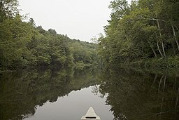
Seguin River
| Seguin River | |
| River | |
|
Seguin River
|
|
| Name origin: From the Ojibwe ziigwan, meaning "spring" | |
| Country | Canada |
|---|---|
| Province | Ontario |
| Region | Central Ontario |
| District | Parry Sound |
| Tributaries | |
| - left | Little Seguin River |
| - right | Manitoubwabing River |
| Source | Bear Lake |
| - location | Bear Lake, McMurrich/Monteith |
| - elevation | 314 m (1,030 ft) |
| - coordinates | 45°27′23″N 79°35′19″W / 45.45639°N 79.58861°W |
| Mouth | |
| - location | Parry Sound |
| - elevation | 176 m (577 ft) |
| - coordinates | 45°20′21″N 80°02′03″W / 45.33917°N 80.03417°WCoordinates: 45°20′21″N 80°02′03″W / 45.33917°N 80.03417°W |
| Length | 40 km (25 mi) |
| Basin | 1,023 km2 (395 sq mi) |
The Seguin River is a river in Parry Sound District in central Ontario, Canada that empties into Parry Sound on Georgian Bay, Lake Huron at the town of Parry Sound. The river's name comes from the Ojibwe word ziigwan, meaning "spring".
The Seguin River begins at Horn Lake near the community of Bear Lake in the municipality of McMurrich/Monteith. It is joined by a tributary off of Bear lake, then turns southwest and enters the township of Seguin, flows through Upper Fry Lake and Lower Fry Lake and passes north over a series of waterfalls near the community of Seguin Falls, at which point it is crossed by the former path of the Ottawa, Arnprior and Parry Sound Railway, now the recreational Seguin Trail rail trail. The river turns again southwest into Isabella Lake where it takes in the left tributary Little Seguin River. It continues southwest over the Serpent Rapids, the Indian Rapids and the Hab Rapids, passes into the township of McDougall, and takes in the right tributary Manitouwabing River. The Seguin continues through Mountain Chute to reach Mill Lake in the town of Parry Sound, where it takes in the left tributary Haines Creek, heads under Ontario Highway 400 then over Mill Lake Dam, and takes in the right tributary Darlington's Creek. It then flows under a low bridge carrying the Canadian National Railway main line, over the Cascade Street Dam and Cascade Street Generating Station, over the Trestle Dam, under the high Parry Sound CPR Trestle that carries the Canadian Pacific Railway, and reaches its mouth at Parry Sound.
...
Wikipedia


