Seelow
| Seelow | ||
|---|---|---|

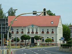
Seelow Town Hall
|
||
|
||
| Coordinates: 52°31′00″N 14°22′59″E / 52.51667°N 14.38306°ECoordinates: 52°31′00″N 14°22′59″E / 52.51667°N 14.38306°E | ||
| Country | Germany | |
| State | Brandenburg | |
| District | Märkisch-Oderland | |
| Government | ||
| • Mayor | Jörg Schröder (Ind.) | |
| Area | ||
| • Total | 25.28 km2 (9.76 sq mi) | |
| Elevation | 52 m (171 ft) | |
| Population (2015-12-31) | ||
| • Total | 5,387 | |
| • Density | 210/km2 (550/sq mi) | |
| Time zone | CET/CEST (UTC+1/+2) | |
| Postal codes | 15306 | |
| Dialling codes | 03346 | |
| Vehicle registration | MOL, FRW, SEE, SRB | |
| Website | Official website | |
Seelow is a German town, seat of the Märkisch-Oderland, a district of Brandenburg. As of 2013 its population was of 5,464.
It is situated in the extreme east of Germany, 70 km (40 miles) east of Berlin, 16 km (10 miles) west of the boundary with Poland.
The village appears in the records held in 1252 by Archbishop Wilbrand of Magdeburg. At that time, listed as Villa Zelou, it was included in the property of the formerly Polish Bishopric of Lebus (Lubusz Land), contested between the Magdeburg archbishops and the Ascanian margraves of Brandenburg.
Seelow suffered damaging town fires in 1630, 1788 and again in 1809.
From 1816 Seelow was included for administrative purposes in the Lebus district, a subdivision of the Frankfurt Region within the Prussian Province of Brandenburg. In 1863 the district council office was relocated to Seelow and in 1950 "Lebus district" was renamed "Seelow district"; following frontier changes agreed with the Soviet Union in 1945, the town of Lebus itself had lost to Poland much of the agricultural area that had traditionally supported it. Between 1952 and 1993, Seelow was the administrative centre for the eponymous district within the larger Frankfurt territory.
...
Wikipedia


