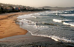
Scottburgh, KwaZulu-Natal
| Scottburgh | |
|---|---|

Scottburgh Beach
|
|
|
|
|
| Coordinates: 30°17′S 30°45′E / 30.283°S 30.750°ECoordinates: 30°17′S 30°45′E / 30.283°S 30.750°E | |
| Country | South Africa |
| Province | KwaZulu-Natal |
| District | Ugu |
| Municipality | Umdoni |
| Established | 1860 |
| Area | |
| • Total | 23.80 km2 (9.19 sq mi) |
| Elevation | 19 m (62 ft) |
| Population (2011) | |
| • Total | 11,403 |
| • Density | 480/km2 (1,200/sq mi) |
| Racial makeup (2011) | |
| • Black African | 27.7% |
| • Coloured | 3.0% |
| • Indian/Asian | 22.0% |
| • White | 46.8% |
| • Other | 0.6% |
| First languages (2011) | |
| • English | 68.0% |
| • Zulu | 16.0% |
| • Afrikaans | 11.2% |
| • Xhosa | 2.1% |
| • Other | 2.7% |
| Postal code (street) | 4180 |
| PO box | 4180 |
| Area code | 039 |
Scottburgh (pronounced scott-burra,) is a coastal resort town situated on the mouth of the Mpambanyoni River (confuser of birds), 58 km south of Durban on the KwaZulu-Natal South Coast in South Africa. Neighbouring towns include Pennington, Renishaw, Freeland Park, Umkomaas, Sezela, Bazley, Amahlongwa, Clansthal, Park Rynie and Dududu.
Named after Natal Colony Governor John Scott and in 1860 it became the first township to be laid out south of Durban, but was initially known as Devonport. Scottburgh then became a very promising port as well as a new attractive location for sugar farms and sugar mills. In about 1850 the town started to attract immigrants especially from the United Kingdom, known as the Byrne Settlers. They came to take advantage of the good harbours, both locally and at Durban, and to export their sugar both internally and externally. Scottburgh became a municipality in 1964.
Scottburgh Main beach along with Pennington and Park Rynie have been awarded blue flag status as of the 2014/15 summer season. Scottburgh and Pennington are both very popular for tourists to make their way to the beach. Scottburgh along with the two hotels and many B+B's is also home to an award winning caravan park and camping ground. The summer season sees many tourists from the inland flock to the beaches of the South Coast.
Scottburgh is a bay situated on the South Bank of the Mpambanyoni River, a short river that culminates in a lagoon. It is one of the best geographic examples of a bay on the South African coast. Mpambanyoni mouth has fluctuated in surface area and volume dramatically over the years, largely due to the frequent droughts, occasional cyclones, and other extreme weather conditions that can affect KwaZulu-Natal.
Scottburgh can be separated into neighbourhoods: Scottburgh Central (north), Scottburgh South, Freeland Park (which is situated on the north side of the Mpambanyoni River).
Most notorious of the above-mentioned cyclones was Cyclone Demoina of 1984 and the floods of 1987, which resulted in widespread flooding and infrastructural damage, including the destruction of the Old Main Road bridge from Durban and Umkomaas.
...
Wikipedia


