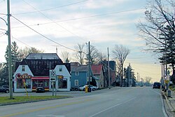
Scone, Ontario
| Chatsworth | |
|---|---|
| Township (lower-tier) | |
| Township of Chatsworth | |
 |
|
| Location in southern Ontario | |
| Coordinates: 44°23′N 80°52′W / 44.38°N 80.87°WCoordinates: 44°23′N 80°52′W / 44.38°N 80.87°W | |
| Country |
|
| Province |
|
| County | Grey |
| Formed | January 1, 2001 |
| Government | |
| • Mayor | Bob Pringle |
| • Federal riding | Bruce—Grey—Owen Sound |
| • Prov. riding | Bruce—Grey—Owen Sound |
| Area | |
| • Land | 596.17 km2 (230.18 sq mi) |
| Population (2011) | |
| • Total | 6,437 |
| • Density | 10.7/km2 (28/sq mi) |
| Time zone | EST (UTC-5) |
| • Summer (DST) | EDT (UTC-4) |
| Postal Code | N0H 1G0 |
| Area code(s) | 519 and 226 |
| Highways |
|
| Website | www |
Chatsworth is a township in south-western Ontario, Canada, in Grey County, located at the headwaters of the Styx River, the Saugeen River, the Sauble River, the Bighead River, the Spey River, and the old Sydenham River.
The current township was formed in late year 2000 with the amalgamation of Holland Township, Sullivan Township, and the village of Chatsworth. The first white settlers arrived in this area in the early 19th century and a significant amount of settlement was underway in mid-to-late 1800s. The township is currently led by a municipal government containing a Mayor, a Deputy Mayor and three Council Members. The current government is Bob Pringle as Mayor; Scott Mackey as Deputy mayor; and Shawn Greig, Brian Gamble and Elizabeth Thompson as Councillors. The next municipal election is October 27, 2018 as part of the 2018 Ontario Municipal Elections.
Canadian suffragette and activist Nellie McClung was born in the town of Chatsworth.
The Sullivan Township area has a large Amish population.
In addition to the town of Chatsworth itself, the township comprises the communities of Arnott, Berkeley, Desboro, Dornoch, Glascott, Grimston, Harkaway, Hemstock Mill, Holford, Holland Centre, Keady, Keward, Kinghurst, Lily Oak, Lueck Mill, Marmion, Massie, Mooresburg, Mount Pleasant, Peabody, Scone, Strathaven, Walters Falls, Williams Lake, and Williamsford.
Arnott's first post office opened on January 4, 1868. Arnott's location has not been shown on road maps since 1976 when Highway 10 was surveyed and rerouted. Arnott had a population of 70 in 1864; it was approximately 50 in 1887. The hamlet was originally called "Murray's Corner" but was renamed "Arnott" after a Francis Arnott who was given a grant to settle the area.
The post office in Berkeley was established in 1853 when the settlement was originally called "Holland". It was renamed "Berkeley" in 1857. The post office also housed the general store which operated under various proprietors until 1974 when it was phased out of operation.
...
Wikipedia

