Schwarzenberg, Saxony
| Schwarzenberg | ||
|---|---|---|
 |
||
|
||
| Coordinates: 50°32′43″N 12°46′45″E / 50.54528°N 12.77917°ECoordinates: 50°32′43″N 12°46′45″E / 50.54528°N 12.77917°E | ||
| Country | Germany | |
| State | Saxony | |
| District | Erzgebirgskreis | |
| Government | ||
| • Mayor | Heidrun Hiemer (CDU) | |
| Area | ||
| • Total | 46.25 km2 (17.86 sq mi) | |
| Elevation | 468 m (1,535 ft) | |
| Population (2015-12-31) | ||
| • Total | 17,391 | |
| • Density | 380/km2 (970/sq mi) | |
| Time zone | CET/CEST (UTC+1/+2) | |
| Postal codes | 08340 | |
| Dialling codes | 03774 | |
| Vehicle registration | ERZ, ANA, ASZ, AU, MAB, MEK, STL, SZB, ZP | |
| Website | www.schwarzenberg.de | |
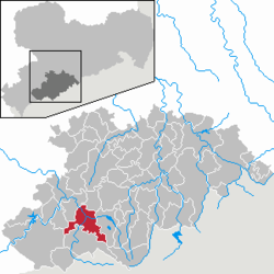
Schwarzenberg is a town in the district of Erzgebirgskreis in Saxony’s Ore Mountains, near the German–Czech border. The town lies roughly 15 km southeast of Aue, and 35 km southwest of Chemnitz.
Founded in the 12th century to protect a trade road, the small mountain town became the centre of a territory known as Herrschaft Schwarzenberg and later Amt Schwarzenberg. During the division of Germany, Schwarzenberg was part of East Germany and became the greatest producer of washing machines in Eastern Europe. Schwarzenberg became more widely known in 1987, when Stefan Heym coined the term Free Republic of Schwarzenberg for a small gap between the Soviet and American occupation zones in May/June 1945.
Schwarzenberg is in the southwestern Ore Mountains. It lies at elevations stretching from 428.5 to 823 metres (1,406 to 2,700 ft) above sea level. The Old Town with church and castle is located on a rock (the Schlossberg, 593 metres (1,946 ft)) around which a meander of the River Schwarzwasser has formed; the Mittweida flows into the Schwarzwasser inside the town. However, the town's overall situation is in a basin. The most prominent peaks surrounding it, in addition to the Schlossberg, are the Hirschstein (641 metres (2,103 ft)), the Hohe Hahn (674 metres (2,211 ft)), the Hohe Henne (728 metres (2,388 ft)), the Rockelmann (580 metres (1,900 ft)), the Galgenberg (557 metres (1,827 ft)) and the Raschau Knochen (551 metres (1,808 ft)).
The town's silhouette is marked by the opposing rocks Ottenstein and Totenstein, which like the Schlossberg consist of Augen gneiss. Other stones include quartz (only some of it pure as rock crystal), biotite, muscovite and feldspar. The Schwarzenberg mining area is pervaded by ore veins of complex origin. Skarn deposits contain magnetite, iron pyrite, arsenopyrite, chalcopyrite, sphalerite and galena. The ore deposits are up to 6 metres thick and permeated by silver and cobalt minerals as well as cassiterite.
...
Wikipedia


