Schwäbisch Gmünd
| Schwäbisch Gmünd | ||
|---|---|---|

View from Mt. Zeiselberg
|
||
|
||
| Coordinates: 48°48′N 9°48′E / 48.800°N 9.800°ECoordinates: 48°48′N 9°48′E / 48.800°N 9.800°E | ||
| Country | Germany | |
| State | Baden-Württemberg | |
| Admin. region | Stuttgart | |
| District | Ostalbkreis | |
| Government | ||
| • Lord Mayor | Richard Arnold | |
| Area | ||
| • Total | 113.78 km2 (43.93 sq mi) | |
| Elevation | 321 m (1,053 ft) | |
| Population (2015-12-31) | ||
| • Total | 59,840 | |
| • Density | 530/km2 (1,400/sq mi) | |
| Time zone | CET/CEST (UTC+1/+2) | |
| Postal codes | 73525–73529 | |
| Dialling codes | 07171 | |
| Vehicle registration | AA, GD | |
| Website | www.schwaebisch-gmuend.de | |
| Imperial City of [Swabian] Gmünd | ||||||||||
| Reichsstadt [Schwäbisch] Gmünd | ||||||||||
| Free Imperial City of the Holy Roman Empire | ||||||||||
|
||||||||||
| Capital | Schwäbisch Gmünd | |||||||||
| Government | Republic | |||||||||
| Historical era | Middle Ages | |||||||||
| • | Founded | mid-12th century | ||||||||
| • | Gained Reichsfreiheit | 1268 | ||||||||
| • | Mediatised to Württemberg | 1802 | ||||||||
|
||||||||||
Schwäbisch Gmünd (German pronunciation: [ˈʃvɛːbɪʃ ˈɡmʏnt], until 1934: Gmünd) is a town in the eastern part of the German state of Baden-Württemberg. With a population of around 60,000, the town is the second largest in the Ostalb district and the whole East Württemberg region after Aalen. The town is a Große Kreisstadt since 1956, i.e. a chief town under district administration; it was the administrative capital of its own rural district until the local government reorganisation on 1 January 1973.
Schwäbisch Gmünd was a self-ruling free imperial city from the 13th century until its annexation to Württemberg in 1802.
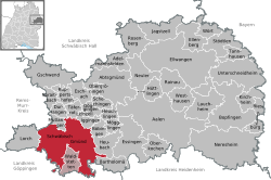
Schwäbisch Gmünd is situated within the northern foothills of the Swabian Jura Mountains on the Rems river, about 50 kilometres (31 miles) east of the state capital Stuttgart. The municipal area comprises the localities (Ortschaften) of Bargau, Bettringen, Degenfeld, Großdeinbach, Herlikofen, Hussenhofen, Lindach, Rechberg, Rehnenhof-Wetzgau, Straßdorf, and Weiler.
From about 85 AD, the Neckar-Odenwald line was part of the northern frontier of the Roman Empire. The Romans built the Limes Germanicus to secure this border, i.e. a line of fortifications in regular distances, which included a small castrum on the site of the present-day Schirenhof field in Schwäbisch Gmünd. A first major settlement in this area arose around the 2nd century AD, when Roman soldiers were deployed near the Upper Germanic Limes. From 223 onwards the border lines were assaulted and taken by the Alemanni, who settled down in the areas abandoned by the Romans.
...
Wikipedia


