Schuyler County, Missouri
| Schuyler County, Missouri | |
|---|---|

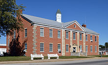
Schuyler County court house in Lancaster
|
|
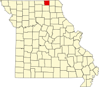
 Location in the U.S. state of Missouri |
|
 Missouri's location in the U.S. |
|
| Founded | February 14, 1845 |
| Named for | Philip Schuyler |
| Seat | Lancaster |
| Largest city | Lancaster |
| Area | |
| • Total | 308 sq mi (798 km2) |
| • Land | 307 sq mi (795 km2) |
| • Water | 0.9 sq mi (2 km2), 0.3% |
| Population (est.) | |
| • (2015) | 4,436 |
| • Density | 14/sq mi (5/km²) |
| Congressional district | 6th |
| Time zone | Central: UTC-6/-5 |
| Schuyler County, Missouri | ||||
|---|---|---|---|---|
| Elected countywide officials | ||||
| Assessor | Gary Stump | Democratic | ||
| Circuit Clerk | Judy Keim | Democratic | ||
| County Clerk | Bree Shaw | Democratic | ||
| Collector | Kathy Roberts | Democratic | ||
|
Commissioner (Presiding) |
Rodney Cooper | Republican | ||
|
Commissioner (District 1) |
Jim Werner | Democratic | ||
|
Commissioner (District 2) |
Donald Crabtree | Republican | ||
| Coroner | Douglas B. Norman | Democratic | ||
| Prosecuting Attorney | H. Scott Summers | Democratic | ||
| Public Administrator | Ronald L. Morgan | Democratic | ||
| Recorder | Linda Blessing | Republican | ||
| Sheriff | Carl Gottman | Democratic | ||
| Surveyor | Adam Mitchell | Republican | ||
| Treasurer | Karmen Buckallew | Democratic | ||
Schuyler County is a county located in the northeastern portion of the U.S. state of Missouri. As of the 2010 census, the population was 4,431, making it the fourth-least populous county in Missouri. Its county seat is Lancaster. The county was organized February 14, 1845, and named for General Philip Schuyler, delegate to the Continental Congress and U.S. Senator from New York.
Schuyler County is part of the Kirksville, MO Micropolitan Statistical Area.
The USS Schuyler (AK-209), a World War II-era cargo ship, was named in part for Schuyler County, Missouri.
According to the U.S. Census Bureau, the county has a total area of 308 square miles (800 km2), of which 307 square miles (800 km2) is land and 0.9 square miles (2.3 km2) (0.3%) is water. It is the second-smallest county in Missouri by area. Schuyler County borders Iowa to the north.
As of the census of 2010, there were 4,431 people, 1,725 households, and 1,193 families residing in the county. The population density was 14 people per square mile (5/km²). There were 2,027 housing units at an average density of 7 per square mile (3/km²). The racial makeup of the county was 98.44% White, 0.05% Black or African American, 0.31% Native American, 0.17% Asian, 0.02% Pacific Islander, 0.17% from other races, and 0.84% from two or more races. Approximately 0.65% of the population were Hispanic or Latino of any race.
...
Wikipedia
