Schloßböckelheim
| Schloßböckelheim | ||
|---|---|---|
|
||
| Coordinates: 49°48′22″N 7°44′37″E / 49.80611°N 7.74361°ECoordinates: 49°48′22″N 7°44′37″E / 49.80611°N 7.74361°E | ||
| Country | Germany | |
| State | Rhineland-Palatinate | |
| District | Bad Kreuznach | |
| Municipal assoc. | Rüdesheim | |
| Government | ||
| • Mayor | Rudolf Staab | |
| Area | ||
| • Total | 4.76 km2 (1.84 sq mi) | |
| Elevation | 125-303 m (−869 ft) | |
| Population (2015-12-31) | ||
| • Total | 373 | |
| • Density | 78/km2 (200/sq mi) | |
| Time zone | CET/CEST (UTC+1/+2) | |
| Postal codes | 55596 | |
| Dialling codes | 06758 | |
| Vehicle registration | KH | |
| Website | www.schlossboeckelheim.de | |
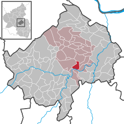
Schloßböckelheim (or Schlossböckelheim) is an Ortsgemeinde – a municipality belonging to a Verbandsgemeinde, a kind of collective municipality – in the Bad Kreuznach district in Rhineland-Palatinate, Germany. It belongs to the Verbandsgemeinde of Rüdesheim, whose seat is in the municipality of Rüdesheim an der Nahe. Schloßböckelheim is a winegrowing village.
In terms of geographical landscape regions, Schloßböckelheim and its surrounding countryside belong to the Lower Naheland, which is framed to the northwest by the Soonwald’s southern foothills, to the south by the North Palatine Uplands and to the east by Rhenish Hesse and the Rhine itself. The area lies in the west of the Nahe-Alsenz Felsenland ("rock country") at the transitional zone leading into the Sobernheim valley broadening. The village itself lies roughly 10 km southwest of the district seat of Bad Kreuznach. Schloßböckelheim sits at elevations ranging from 125 to 303 m above sea level, and its municipal area measures 4.76 km².
Clockwise from the north, Schloßböckelheim’s neighbours are the municipalities of Weinsheim, Hüffelsheim, Niederhausen, Oberhausen an der Nahe and Waldböckelheim, all of which likewise lie within the Bad Kreuznach district.
...
Wikipedia


