Schliengen
| Schliengen | ||
|---|---|---|

Schliengen
|
||
|
||
| Coordinates: 47°45′20″N 7°34′38″E / 47.75556°N 7.57722°ECoordinates: 47°45′20″N 7°34′38″E / 47.75556°N 7.57722°E | ||
| Country | Germany | |
| State | Baden-Württemberg | |
| Admin. region | Freiburg | |
| District | Lörrach | |
| Government | ||
| • Mayor | Werner Bundschuh (FDP/DVP) | |
| Area | ||
| • Total | 37.46 km2 (14.46 sq mi) | |
| Population (2015-12-31) | ||
| • Total | 5,448 | |
| • Density | 150/km2 (380/sq mi) | |
| Time zone | CET/CEST (UTC+1/+2) | |
| Postal codes | 79418 | |
| Dialling codes | 07635 | |
| Vehicle registration | LÖ | |
| Website | www.schliengen.de | |
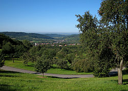
Schliengen is a town in southwestern Germany in the state of Baden-Württemberg, in the Kreis (district) of Lörrach. Schliengen's claim to international fame is the Battle of Schliengen (24 October 1796), fought between forces of the French Revolutionary army under Jean-Victor Moreau and the Austrian army under Karl von Österreich-Teschen. As both sides claimed victory, the battle is commemorated on a monument in Vienna and on the Arc de Triomphe in Paris.
The town of Schliengen is located in the Markgräflerland between Müllheim and the district town of Lörrach. The area of the municipality stretches from the Upper Rhine Plain (elev. 225 m/738 ft) to the top of the Blauen or Hochblauen (elev. 1165 m/3,822 ft).
The municipality of Schliengen is bordered on the north by Auggen, in the northeast by Feldberg (a borough of Müllheim), both of which are in Kreis (district) Breisgau-Hochschwarzwald, in the east by Malsburg-Marzell, in the south by the towns of Kandern and Bad Bellingen, and on the west by Steinenstadt, a borough of Neuenburg am Rhein, which is again in the Breisgau-Hochschwarzwald district.
The municipality of Schliengen contains the following boroughs (); Liel, Mauchen, Niedereggenen, Obereggenen and Schallsingen.
Lutheran Churches exist in Niedereggenen, Obereggenen and Feldberg.
...
Wikipedia


