Scarborough Centre (electoral district)
|
|
|||
|---|---|---|---|

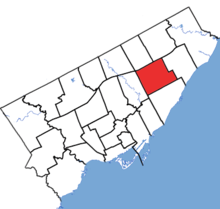
Scarborough Centre in relation to the other Toronto ridings (2015 boundaries)
|
|||
| Federal electoral district | |||
| Legislature | House of Commons | ||
| MP |
Liberal |
||
| District created | 1976 | ||
| First contested | 1979 | ||
| Last contested | 2015 | ||
| District webpage | profile, map | ||
| Demographics | |||
| Population (2011) | 108,826 | ||
| Electors (2015) | 70,145 | ||
| Area (km²) | 30 | ||
| Pop. density (per km²) | 3,627.5 | ||
| Census divisions | Toronto | ||
| Census subdivisions | Toronto | ||
Coordinates: 43°46′N 79°15′W / 43.767°N 79.250°W
Scarborough Centre (French: Scarborough-Centre) is a federal electoral district in Ontario, Canada, that has been represented in the House of Commons of Canada since 1979.
The riding was created in 1976 from parts of Scarborough East, Scarborough West and York—Scarborough ridings.
It consists of the part of the Scarborough district of the City of Toronto bounded:
Notable landmarks in Scarborough Centre include:
It has been represented in the House of Commons by Liberal MP Salma Zahid since 2015.
The riding contains the neighbourhoods of Scarborough City Centre (west of McCowan Road), Bendale (west of McCowan and south of Lawrence), Eglinton East, Ionview (north of Eglinton Avenue), Golden Mile (north of Eglinton Avenue), Wexford, Maryvale, and Dorset Park.
...
Wikipedia
