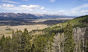
Sawtooth National Forest
| Sawtooth National Forest | |
|---|---|
|
IUCN category VI (protected area with sustainable use of natural resources)
|
|

|
|
| Location | Blaine, Boise, Camas, Cassia, Custer, Elmore, Oneida, Power, and Twin Falls counties, Idaho, and Box Elder County, Utah, United States |
| Nearest city | Twin Falls, ID |
| Coordinates | 43°44′N 114°40′W / 43.733°N 114.667°WCoordinates: 43°44′N 114°40′W / 43.733°N 114.667°W |
| Area | 2,110,408 acres (8,540.52 km2) (administered); 1,802,133 acres (7,292.97 km2) (proclaimed) |
| Established | May 29, 1905 |
| Visitors | 1,188,600 (in 2005) |
| Governing body | U.S. Forest Service |
| Website | Sawtooth National Forest |
| Stanley, Idaho | ||||||||||||||||||||||||||||||||||||||||||||||||||||||||||||
|---|---|---|---|---|---|---|---|---|---|---|---|---|---|---|---|---|---|---|---|---|---|---|---|---|---|---|---|---|---|---|---|---|---|---|---|---|---|---|---|---|---|---|---|---|---|---|---|---|---|---|---|---|---|---|---|---|---|---|---|---|
| Climate chart () | ||||||||||||||||||||||||||||||||||||||||||||||||||||||||||||
|
||||||||||||||||||||||||||||||||||||||||||||||||||||||||||||
|
||||||||||||||||||||||||||||||||||||||||||||||||||||||||||||
| J | F | M | A | M | J | J | A | S | O | N | D |
|
1.6
26
−1
|
1.3
33
0
|
1.1
42
9
|
1.1
50
20
|
1.3
60
28
|
1.2
68
33
|
0.6
79
36
|
0.6
78
33
|
0.8
69
27
|
1
56
21
|
1.5
39
12
|
1.6
26
−1
|
| Average max. and min. temperatures in °F | |||||||||||
| Precipitation totals in inches | |||||||||||
| Source: NOAA, | |||||||||||
| Metric conversion | |||||||||||
|---|---|---|---|---|---|---|---|---|---|---|---|
| J | F | M | A | M | J | J | A | S | O | N | D |
|
41
−3
−18
|
33
1
−18
|
29
5
−13
|
28
10
−7
|
32
15
−2
|
30
20
1
|
15
26
2
|
15
25
0
|
19
20
−3
|
25
Wikipedia
...
| ||

