Savognin
| Savognin | ||
|---|---|---|
| Former municipality of Switzerland | ||
 |
||
|
||
| Coordinates: 46°35′N 09°35′E / 46.583°N 9.583°ECoordinates: 46°35′N 09°35′E / 46.583°N 9.583°E | ||
| Country | Switzerland | |
| Canton | Grisons | |
| District | Albula | |
| Area | ||
| • Total | 22.23 km2 (8.58 sq mi) | |
| Elevation | 1,207 m (3,960 ft) | |
| Population (Dec 2014) | ||
| • Total | 1,016 | |
| • Density | 46/km2 (120/sq mi) | |
| Postal code | 7460 | |
| SFOS number | 3539 | |
| Surrounded by | Cunter, Filisur, Mulegns, Riom-Parsonz, Tiefencastel, Tinizong-Rona | |
| Website |
www SFSO statistics |
|
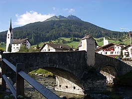
Savognin (in local Romansh dialect Suagnign;Italian: Savognino; German: Schweiningen, official name until 1890) is a village and former municipality in the Sursés in the district of Albula in the canton of Grisons in Switzerland. On 1 January 2016 the former municipalities of Bivio, Cunter, Marmorera, Mulegns, Riom-Parsonz, Salouf, Savognin, Sur and Tinizong-Rona merged to form the new municipality of Surses.
The stately village is the main municipality of the Sursés (German: Oberhalbstein), like the whole region (the major valley of the Gelgia and its side valleys) is called, and is a foreign tourist destination in both, summer and winter. The official language is the Romansh dialect Surmiran.
Savognin is first mentioned in 1154 as Sueningin.
An important Bronze Age settlement is located on the Padnal hill to the south of town. In multiple excavations, many discoveries have been made, mostly from the period between 1800 and 1000 B.C.
At least since the time of the Romans, important travel routes have passed through the Julier and Septimer passes. Savognin came into the possession of the Bishops of Chur in the 13th century. As part of the court of Oberhalbstein, for which Savognin acted as principal town and rural area, the town became a member of the League of God's House. After its sale in 1552, the valley attained full sovereignty as part of the Free State of the Three Leagues.
...
Wikipedia


