Savigny-le-Temple
| Savigny-le-Temple | |
|---|---|
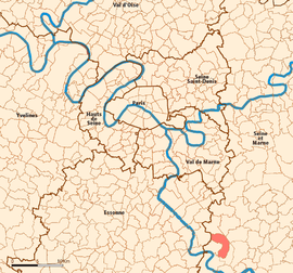
 Location (in red) within Paris inner and outer suburbs |
|
| Coordinates: 48°35′03″N 2°35′00″E / 48.5841°N 2.5832°ECoordinates: 48°35′03″N 2°35′00″E / 48.5841°N 2.5832°E | |
| Country | France |
| Region | Île-de-France |
| Department | Seine-et-Marne |
| Arrondissement | Melun |
| Canton | Savigny-le-Temple |
| Intercommunality | Sénart |
| Government | |
| • Mayor (2008–2014) | Marie-Line PICHERY |
| Area1 | 11.97 km2 (4.62 sq mi) |
| Population (2006)2 | 25,398 |
| • Density | 2,100/km2 (5,500/sq mi) |
| Time zone | CET (UTC+1) |
| • Summer (DST) | CEST (UTC+2) |
| INSEE/Postal code | 77445 / 77176 |
| Elevation | 58–91 m (190–299 ft) (avg. 77 m or 253 ft) |
|
1 French Land Register data, which excludes lakes, ponds, glaciers > 1 km² (0.386 sq mi or 247 acres) and river estuaries. 2Population without double counting: residents of multiple communes (e.g., students and military personnel) only counted once. |
|
1 French Land Register data, which excludes lakes, ponds, glaciers > 1 km² (0.386 sq mi or 247 acres) and river estuaries.
Savigny-le-Temple is a commune in the Seine-et-Marne Department of France in the Île-de-France in north-central France. It is located in the south-eastern suburbs of Paris, 33.2 km (20.6 mi) from the center of Paris. It is the largest commune in the "new town" of Sénart, created in the 1970s.
During the French Revolution, Savigny-le-Temple (meaning "Savigny the temple") was temporarily renamed Savigny-sur-Balory (meaning "Savigny upon Balory", after the small Balory river). It was also temporarily renamed Savigny-le-Port (meaning "Savigny the port"). These changes were probably motivated by the religious connotation of the word "temple".
Inhabitants of Savigny-le-Temple are called Savigniens.
Savigny-le-Temple is served by Savigny-le-Temple – Nandy station on Paris RER line ![]() .
.
...
Wikipedia
