Savannah, New York
| Savannah, New York | |
|---|---|
| Town | |
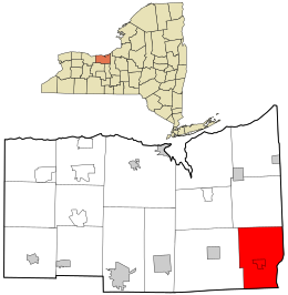
 Location in Wayne County and the state of New York. |
|
| Location within the state of New York | |
| Coordinates: 43°4′30″N 76°45′36″W / 43.07500°N 76.76000°WCoordinates: 43°4′30″N 76°45′36″W / 43.07500°N 76.76000°W | |
| Country | United States |
| State | New York |
| County | Wayne |
| Settled | 1808 |
| Established | November 24, 1824 |
| Government | |
| • Type | Town Board |
| • Supervisor | Michael Kolczynski |
| • Clerk | Julie Carey |
| • Court | Justice Richard R. Sloan Justice Heath E. TenEyck |
| Area | |
| • Total | 36.2 sq mi (93.7 km2) |
| • Land | 36.0 sq mi (93.2 km2) |
| • Water | 0.2 sq mi (0.5 km2) |
| Elevation | 394 ft (120 m) |
| Population (2010) | |
| • Total | 1,730 |
| • Density | 48.1/sq mi (18.6/km2) |
| Time zone | Eastern (EST) (UTC-5) |
| • Summer (DST) | EDT (UTC-4) |
| ZIP code | 13146 |
| Area code(s) | 315 |
| FIPS code | 36-65343 |
| GNIS feature ID | 0979465 |
Savannah is a town in the southeast portion of Wayne County, New York, United States. The population was 1,730 at the 2010 census.
The town has a hamlet (and census-designated place), also called Savannah. Government offices for the town are located there.
Fort Hill, located on the highest land in the town, is a historic native village and was the site of a Jesuit mission in the 17th Century, built by the remains of an earlier, "Owasco," village. Like other nearby towns, Savannah was part of the Central New York Military Tract. Settlers arrived in more modern times around 1808, but Savannah is considered to be the last town in the county that was settled.
The Town of Savannah was created from the Town of Galen on November 24, 1824.
Wiley Schoolhouse (built 1874) is a fully restored historic one-room school for the former District #11 located at the intersection of Wiley (CR 374), Hogback and Olmstead roads in the southwest part of town. The Crusoe House (built 1824), located on N.Y. Route 89 near Crusoe Lake, is currently the oldest building in the Town of Savannah. Originally a hotel and tavern, the first ever town meeting was held there in April 1825. It also served as the first post office.
According to the United States Census Bureau, the town has a total area of 36.2 square miles (94 km2), of which, 36.0 square miles (93 km2) of it is land and 0.2 square miles (0.52 km2) of it (0.53%) is water.
The east town line is the border of Cayuga County, and the south town line is the border of Seneca County. It is west of Syracuse, New York.
New York State Route 31, an east-west highway, is partly conjoined with New York State Route 89, a north-south highway in the town.
...
Wikipedia

