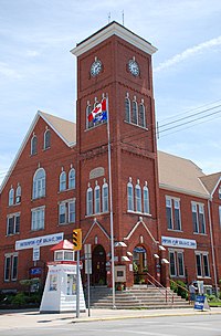
Saugeen Shores
| Saugeen Shores | |
|---|---|
| Town (lower-tier) | |
| Town of Saugeen Shores | |

Old town hall, Southampton
|
|
| Location in southern Ontario | |
| Coordinates: 44°26′N 81°22′W / 44.433°N 81.367°WCoordinates: 44°26′N 81°22′W / 44.433°N 81.367°W | |
| Country |
|
| Province |
|
| County | Bruce |
| Settled | ca. 1850 |
| Formed | 1996 |
| Government | |
| • Mayor | Mike Smith |
| • Deputy Mayor | Luke Charbonneau |
| • Vice Deputy Mayor | Diane Huber |
| • Federal riding | Huron—Bruce |
| • Prov. riding | Huron—Bruce |
| Area | |
| • Land | 170.97 km2 (66.01 sq mi) |
| Population (2011) | |
| • Total | 12,661 |
| • Density | 74.1/km2 (192/sq mi) |
| Time zone | EST (UTC-5) |
| • Summer (DST) | EDT (UTC-4) |
| Postal Code | N0H |
| Area code(s) | 519 and 226 |
| Website | www |
Saugeen Shores is a town in Bruce County, Ontario, Canada, formed in the 1990s, as municipal restructuring merged the towns of Southampton, Port Elgin, and the township of Saugeen.
In addition to the two main population centres of Southampton and Port Elgin, the town also includes a portion of the communities of Burgoyne and North Bruce, straddling the municipal eastern and southern boundary respectively.
Saugeen Shores traces its history back to 1847 when government agents arrived to survey land at the Saugeen River's mouth. Southampton was Ontario's northernmost lake port, and the first port on the Bruce Coast. By 1852, over 12 families lived there, sustained by the thriving fishery. Settlers continued to arrive from Scotland, Ireland, England, and Germany. By 1857, there were 130 homes, six shops, two hotels, five warehouses, a planing mill, a gristmill, and a steam sawmill. Post and customs offices assured the village's growth, becoming a town in 1904. Saugeen Township's first settler, Alexander Wallace, arrived in early 1851. A few years later, land was available for two dollars an acre and earnest settlement of Bruce County's smallest township began. Land was cleared, and the rich soil yielded many agricultural products, marking the start of a still thriving industry.
In 1859, the Chantry Island Imperial lighthouse was completed, steering sailors clear of the island's dangerous shoals.
The village of Port Elgin was born in 1849, when Lachlan McLean built a shanty and settled there for the winter. For several years he ran a tavern, his patrons consisting primarily of settlers and sailors passing through the little port. By 1854, the community had three houses, a tavern, and mill. Shops, churches, schools, and roads followed, and ten years later the population totalled six hundred and thirty. Early industries included a steam sawmill, foundry, and woolen mill. In 1873, the railway arrived, allowing Southampton and Port Elgin products to travel out into the world.
In 1999, these three municipalities amalgamated to form the Town of Saugeen Shores. The amalgamation created a diverse community with common historical and cultural ties, and a strong economic base. Agriculture, tourism, small business, and energy are the local economy's cornerstones.
According to the 2009 Saugeen Shores Community Profile Census:
Income
Retail Sales
Disposable & Discretionary Income
Labour Force
The major economic activities in this region are agriculture, small business, electricity generation and tourism. The town of Saugeen Shores has recently experienced a boom in development, with the addition of stores such as Walmart and Shopper's Drugmart, plus expansions of Canadian Tire, two Rexall Pharmaplus stores, one in Port Elgin, the other in Southampton. Restaurants such as Chester's Bar & Grill, Andres' Swiss dining, Armen's Rooftop Patio, The Woodpecker Fresh Dining & Lounge, Saffron, and Rosina's Ristorante (Italian) provide unique dishes not common to this area.
...
Wikipedia

