Sarreguemines
| Sarreguemines | ||
|---|---|---|

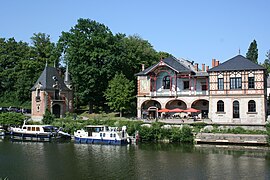
View of the Saar River and the casino
|
||
|
||
| Coordinates: 49°07′N 7°04′E / 49.11°N 7.07°ECoordinates: 49°07′N 7°04′E / 49.11°N 7.07°E | ||
| Country | France | |
| Region | Grand Est | |
| Department | Moselle | |
| Arrondissement | Sarreguemines | |
| Canton | Sarreguemines | |
| Intercommunality | Sarreguemines Confluences | |
| Government | ||
| • Mayor (2014-2020) | Céleste Lett | |
| Area1 | 29.67 km2 (11.46 sq mi) | |
| Population (2013)2 | 21,572 | |
| • Density | 730/km2 (1,900/sq mi) | |
| Time zone | CET (UTC+1) | |
| • Summer (DST) | CEST (UTC+2) | |
| INSEE/Postal code | 57631 / 57200 | |
| Elevation | 192–293 m (630–961 ft) | |
| Website | sarreguemines.fr | |
|
1 French Land Register data, which excludes lakes, ponds, glaciers > 1 km² (0.386 sq mi or 247 acres) and river estuaries. 2Population without double counting: residents of multiple communes (e.g., students and military personnel) only counted once. |
||
1 French Land Register data, which excludes lakes, ponds, glaciers > 1 km² (0.386 sq mi or 247 acres) and river estuaries.
Sarreguemines (French pronunciation: [saʁɡəmin]; German: ![]() Saargemünd , Lorraine Franconian: Saargemìnn) is a commune in the Moselle department of the Grand Est administrative region in north-eastern France.
Saargemünd , Lorraine Franconian: Saargemìnn) is a commune in the Moselle department of the Grand Est administrative region in north-eastern France.
It is the seat of an arrondissement and a canton. As of the 2013 France census, the town's population is 21,572. The inhabitants of the commune are known as Sarregueminois and Sarregueminoises.
Sarreguemines, whose name is a French spelling of the name in local Lorraine-German dialect "Saargemin", meaning "confluence into the Saar", is located at the confluence of the Blies and the Saar, 40 miles (64 km) east of Metz, 60 miles (97 km) northwest of Strasbourg by rail, and at the junction of the lines to Trier and Saarburg. Traditionally Sarreguemines was the head of river navigation on the Saar, its importance being a depot where boats were unloaded.
...
Wikipedia


