Santa Cruz de Barahona
| Barahona | |
|---|---|
| Santa Cruz de Barahona | |

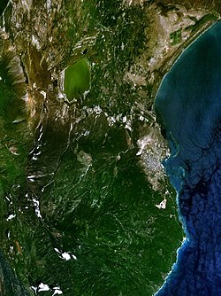
Google Earth image of Barahona.
|
|
| Coordinates: 18°12′N 71°06′W / 18.200°N 71.100°WCoordinates: 18°12′N 71°06′W / 18.200°N 71.100°W | |
| Country |
|
| Province | Barahona |
| Founded /Founder. =Toussaint L'ouverture | 1802 |
| Municipality since | 1858 |
| Area | |
| • Total | 163.02 km2 (62.94 sq mi) |
| Elevation | 10 m (30 ft) |
| Population (2012) | |
| • Total | 138,159 |
| • Density | 850/km2 (2,200/sq mi) |
| • Demonym | Barahonero(a) |
| Municipal Districts | 3 |
| Climate | Aw |
Barahona, also known as Santa Cruz de Barahona, is the main city of the Barahona Province, in the south of the Dominican Republic. It is one of the most important cities on the island, with a very active port and many ecotourism attractions. The city is also a centre of sugar production and industry.
Since the 18th century, the region was occupied by fishermen and people that came here to cut trees. When Toussaint L'Ouverture took the eastern part of the Hispaniola island in the name of France, he gave the order to create the town of Barahona in 1802 as part of the Ozama Department. After the Independence in 1844, Barahona was a military post of the Azua Province.
In 1858, Barahona was elevated to the category of municipality. When the province was created in 1881, Barahona was made its head municipality.
Under the Köppen climate classification, Barahona has a tropical savanna climate. Temperatures tend to remains steady throughout the year, with mean temperatures ranging from a low of 24.8 °C (76.6 °F) in January to a high of 28.0 °C (82.4 °F) in July. In terms of dry and wet seasons, Barahona has two distinctive wet seasons with a peak in precipitation from May to June followed by drought like conditions in July and August (due to the Azores high being located in the central Atlantic, inhibiting the formation of clouds and rain) and another peak in precipitation from September to October. This precipitation pattern is due to the movement and the position of the Azores high throughout the year. The dry season mainly runs through December to April. Even in the drier months, precipitation can stlll occur with February receiving just under 30 mm (1.2 in). Sunshine is abundant throughout the year, averaging over 3200 hours.
...
Wikipedia

