Azua Province
| Azua | |
| Province | |
| Country | |
|---|---|
| Capital | Azua de Compostela |
| - elevation | 83 m (272 ft) |
| - coordinates | 18°27′36″N 70°44′24″W / 18.46000°N 70.74000°WCoordinates: 18°27′36″N 70°44′24″W / 18.46000°N 70.74000°W |
| Area | 2,531.77 km2 (978 sq mi) |
| Population | 298,246 (2014) |
| Density | 118/km2 (306/sq mi) |
| Province since | 1844 |
| Governor | Luis Antonio Vargas Ramírez |
| Subdivisions | 10 municipalities 22 municipal districts |
| Congresspersons | 1 Senator 4 Deputies |
| Timezone | EST (UTC-4) |
| Area code | 1-809 1-829 1-849 |
| ISO 3166-2 | DO-02 |
| Postal Code | 71000 |
|
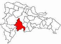
Location of the Azua Province
|
|
Azua (Spanish pronunciation: [ˈaswa]) is a province of the Dominican Republic.
The province as of June 20, 2006 is divided into the following municipalities (municipios) and municipal districts (distrito municipal - D.M.) within them:
The following is a sortable table of the municipalities and municipal districts with population figures as of the 2014 estimate. Urban population are those living in the seats (cabeceras literally heads) of municipalities or of municipal districts. Rural population are those living in the districts (Secciones literally sections) and neighborhoods (Parajes literally places) outside them.The population figures are from the 2014 population estimate.
For comparison with the municipalities and municipal districts of other provinces see the list of municipalities and municipal districts of the Dominican Republic.
...
Wikipedia

