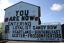
Sandy Row

Former UDA/UFF mural in Sandy Row. Removed in June 2012.
|
|
| Former name(s) | Carr's Row. Name given probably to a row of cottages on the old Lisburn Road (now Sandy Row, near the Saltwater Bridge. This information is from the Ulster Architectural Heritage Society. |
|---|---|
| Maintained by | Belfast City Council |
| Location | Shaftesbury, Belfast |
| Postal code | BT12 5E |
| Coordinates | 54°35′31″N 5°56′13″W / 54.592°N 5.937°WCoordinates: 54°35′31″N 5°56′13″W / 54.592°N 5.937°W |
| North end | Durham Street |
| South end | Lisburn Road |
Sandy Row is a street in south Belfast, Northern Ireland. It lends its name to the surrounding residential community, which is predominantly Protestant working-class. The Sandy Row area had a population of 2,153 in 2001. It is a staunchly loyalist area of Belfast, being a traditional heartland for affiliation with the paramilitary Ulster Defence Association (UDA) and the Orange Order.
Sandy Row is situated in south Belfast, beginning at the edge of the city centre, close to the Europa Hotel. The road runs south from the Boyne Bridge (formerly the Saltwater Bridge) over the old Dublin railway line beside Great Victoria Street station, then crosses the Donegall Road and ends at the bottom of the Lisburn Road. At the north end of the road was the famous Murray's tobacco factory, which was first opened in 1810, while at the other is a large Orange hall.
Formerly known as Carr's Row, Sandy Row is one of the oldest residential areas of Belfast. Its growth in population was in large part due to the expansion of the linen industry in Rowland Street. The name Sandy Row derived from the sandbank which abutted the road that followed the high-water mark resulting from the flow off the tidal waters of the Lagan River estuary. For over two thousand years, the road along the sandbank was the principal thoroughfare leading south from Carrickfergus.
In the 19th century Sandy Row became a bustling shopping district, and by the turn of the 20th-century, there were a total of 127 shops and merchants based in the road. It continued to draw shoppers from all over Belfast until the outbreak of the Troubles in the late 1960s. The rows of 19th-century terraced houses in the streets and backstreets branching off Sandy Row have been demolished and replaced with modern housing. Six of the houses which formerly lined Rowland Street have been rebuilt in the Ulster Folk and Transport Museum.
...
Wikipedia
