Sandy Creek (Michigan)
| Sandy Creek | |
| River | |
|
Sandy Creek looking west from the North Dixie Highway bridge in Frenchtown Charter Township
|
|
| Country | United States |
|---|---|
| State | Michigan |
| Region | Monroe County |
| Tributaries | |
| - left | Little Sandy Creek |
| Source | |
| - location | London Township |
| - elevation | 663 ft (202 m) |
| - coordinates | 42°01′48″N 83°35′31″W / 42.03000°N 83.59194°W |
| Mouth | Lake Erie |
| - location | Sterling State Park / Detroit Beach, Frenchtown Charter Township |
| - elevation | 571 ft (174 m) |
| - coordinates | 41°55′30″N 83°20′02″W / 41.92500°N 83.33389°WCoordinates: 41°55′30″N 83°20′02″W / 41.92500°N 83.33389°W |
| Length | 18.5 mi (30 km) |
|
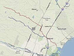
Sandy Creek (red) and Little Sandy Creek (blue) in Monroe County, Michigan
|
|
Sandy Creek is an 18.5-mile-long (29.8 km)creek located entirely within Monroe County, Michigan. The creek rises in London Township in the north-central portion of the county and flows southeast into Lake Erie at Sterling State Park on the south side of Detroit Beach in Frenchtown Charter Township. Along the shores of Sandy Creek was one of the earliest French settlements in the area, known as the Sandy Creek Settlement, which existed from approximately 1780–1813 before being abandoned after the Battle of Frenchtown during the War of 1812.
Aside from its disproportionately large mouth at over 100 feet (30 meters), the creek is very narrow. It is roughly 15–20 feet (4.5–6 m) wide as it passes near its end along Detroit Beach. Before that, it is roughly 5–10 feet (1.5–3 m) wide and can easily be walked or leaped across. Its depth fluctuates relatively high during periods of heavy rainfall, although never to the point where the creek floods. Near the mouth, the creek reaches a depth of roughly 15 feet (4.5 m), but after that, the creek never reaches more than three feet (0.9 m) deep. The creek has a very low discharge and often freezes throughout much of the winter. While the creek is referred to as Sandy Creek, it is actually quite rocky— even rockier than the much larger and longer Stony Creek, which runs parallel about a mile north of Sandy Creek. Common fauna of Sandy Creek include crayfish, pumpkinseed, and carp, although most fishes are found near the mouth and in Lake Erie. Much of the creek after a few hundred yards inland is too shallow to accommodate large fish populations.
Its largest tributary, Little Sandy Creek, rises just about a mile south of the main branch and both flow approximately parallel to one another until merging about two miles before the mouth just before Interstate 75. Sandy Creek has numerous unnamed tributaries. Along with passing under I-75, Sandy Creek travels under North Dixie Highway, North Monroe Street, and U.S. Highway 24 (North Telegraph Road). Neither the creek nor any of its tributaries actually pass through the city limits of Monroe. The sources of Sandy Creek and Little Sandy Creek are indistinguishable, as the area is heavily farmed, and water from numerous artificial irrigation ditches and canals contributes to the creek's origins in the north central portion of the county. Sandy Creek is also the name of a short road that runs parallel to the creek near its ending by Lake Erie. It is also the name of a golf course, in which the creeks runs through, near the creek's beginning far inland.
...
Wikipedia


