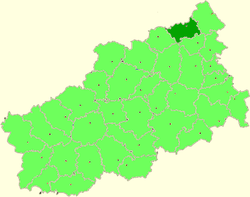
Sandovsky District
| Sandovsky District Сандовский район (Russian) |
|
|---|---|
 Location of Sandovsky District in Tver Oblast |
|
| Coordinates: 58°27′N 36°24′E / 58.450°N 36.400°ECoordinates: 58°27′N 36°24′E / 58.450°N 36.400°E | |
|
|
|
| Location | |
| Country | Russia |
| Federal subject | Tver Oblast |
| Administrative structure (as of 2013) | |
| Administrative center | urban-type settlement of Sandovo |
| Administrative divisions: | |
| Urban settlements | 1 |
| Rural settlements | 4 |
| Inhabited localities: | |
| Urban-type settlements | 1 |
| Rural localities | 215 |
| Municipal structure (as of March 2013) | |
| Municipally incorporated as | Sandovsky Municipal District |
| Municipal divisions: | |
| Urban settlements | 1 |
| Rural settlements | 4 |
| Statistics | |
| Area | 1,608 km2 (621 sq mi) |
| Population (2010 Census) | 6,811 inhabitants |
| • Urban | 51.5% |
| • Rural | 48.5% |
| Density | 4.24/km2 (11.0/sq mi) |
| Time zone | MSK (UTC+03:00) |
| Official website | |
| on | |
Sandovsky District (Russian: Са́ндовский райо́н) is an administrative and municipal district (raion), one of the thirty-six in Tver Oblast, Russia. It is located in the northeast of the oblast and borders with Ustyuzhensky District of Vologda Oblast in the north, Vesyegonsky District in the northeast, Molokovsky District in the southeast, Maksatikhinsky District in the south, Lesnoy District in the west, and with Pestovsky District of Novgorod Oblast in the northwest. The area of the district is 1,608 square kilometers (621 sq mi). Its administrative center is the urban locality (an urban-type settlement) of Sandovo. Population: 6,811 (2010 Census);9,385 (2002 Census);12,495 (1989 Census). The population of Sandovo accounts for 51.5% of the district's total population.
The district lies fully in the basin of the Mologa River. The Mologa itself flows at the western border of the district, separating it from Lesnoy District. Rivers in the north and the west of the district drain directly into the Mologa, whereas rivers in the south and in the center of the district drain into the Melecha, which together with the Mogocha forms the Osen, a right tributary of the Mologa. The source of the Melecha lies within the district. Most of the district is covered by forests.
...
Wikipedia


