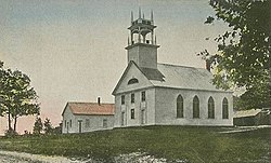
Sanbornton, New Hampshire
| Sanbornton, New Hampshire | ||
|---|---|---|
| Town | ||

Bay Meeting House c. 1910
|
||
|
||
 Location in Belknap County, New Hampshire |
||
| Coordinates: 43°29′28″N 71°35′01″W / 43.49111°N 71.58361°WCoordinates: 43°29′28″N 71°35′01″W / 43.49111°N 71.58361°W | ||
| Country | United States | |
| State | New Hampshire | |
| County | Belknap | |
| Incorporated | 1770 | |
| Government | ||
| • Board of Selectmen | Karen Ober Johnny Van Tassel John Olmstead |
|
| • Town Administrator | Katie Ambrose | |
| Area | ||
| • Total | 49.8 sq mi (128.9 km2) | |
| • Land | 47.6 sq mi (123.3 km2) | |
| • Water | 2.2 sq mi (5.6 km2) 4.32% | |
| Elevation | 824 ft (251 m) | |
| Population (2010) | ||
| • Total | 2,966 | |
| • Density | 62/sq mi (24.1/km2) | |
| Time zone | Eastern (UTC-5) | |
| • Summer (DST) | Eastern (UTC-4) | |
| ZIP code | 03269 | |
| Area code(s) | 603 | |
| FIPS code | 33-67300 | |
| GNIS feature ID | 0873715 | |
| Website | www |
|
Sanbornton is a town in Belknap County, New Hampshire, United States. The population was 2,966 at the 2010 census. It includes the villages of North Sanbornton and Gaza.
Located in the fork of the Pemigewasset and Winnipesaukee rivers, the town was first called Crotchtown. It was granted by Colonial Governor Benning Wentworth in 1748 to his friend John Sanborn of Hampton, along with 59 others from Hampton, Exeter and Stratham. Twelve of the grantees were named Sanborn, therefore the community was named Sanborntown. Among the other settlers were members of the Leavitt family, related to the Sanborns. But ongoing hostilities during the French and Indian War delayed permanent settlement until 1764. It would be incorporated by Governor John Wentworth in 1770. The town originally included Sanbornton Bridge, or Bridge Village, set off in 1869 as Tilton.
According to the United States Census Bureau, the town has a total area of 49.8 square miles (128.9 km2), of which 47.6 sq mi (123.3 km2) is land and 2.2 sq mi (5.6 km2) is water, comprising 4.32% of the town. Bounded on the west by the Pemigewasset River and on the east by Winnisquam Lake, Sanbornton is largely drained by Salmon Brook, a tributary of the Pemigewasset. The highest point in town is the summit of Hersey Mountain, elevation 2,001 feet (610 m) above sea level, along the town's northwestern border.
The town is served by Interstate 93, New Hampshire Route 132, and New Hampshire Route 127. I-93 accesses the town via Exit 22 (NH 127) and leads north to Plymouth and south to Concord. NH 132 parallels I-93 as a local road, connecting Tilton to the south with New Hampton and Ashland to the north. NH 127 intersects NH 132 in the village of Gaza within Sanbornton and leads southwest to Franklin. U.S. Route 3 crosses a very small southeastern corner of Sanbornton at the village of Winnisquam, where the road crosses Winnisquam Lake.
...
Wikipedia

