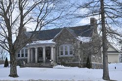
Stratham, New Hampshire
| Stratham, New Hampshire | |
|---|---|
| Town | |

The Stratham Historical Society, housed in the former Wiggin Memorial Library building
|
|
 Location in Rockingham County and the state of New Hampshire. |
|
| Coordinates: 43°01′26″N 70°54′49″W / 43.02389°N 70.91361°WCoordinates: 43°01′26″N 70°54′49″W / 43.02389°N 70.91361°W | |
| Country | United States |
| State | New Hampshire |
| County | Rockingham |
| Incorporated | 1716 |
| Government | |
| • Board of Selectmen | David Canada, Chair Bruno Federico Joseph Lovejoy |
| • Town Administrator | Paul R. Deschaine |
| Area | |
| • Total | 15.5 sq mi (40.1 km2) |
| • Land | 15.1 sq mi (39.1 km2) |
| • Water | 0.4 sq mi (1.0 km2) 2.49% |
| Elevation | 43 ft (13 m) |
| Population (2010) | |
| • Total | 7,255 |
| • Density | 480/sq mi (185.5/km2) |
| Time zone | Eastern (UTC-5) |
| • Summer (DST) | Eastern (UTC-4) |
| ZIP code | 03885 |
| Area code(s) | 603 |
| FIPS code | 33-74340 |
| GNIS feature ID | 0873728 |
| Website | www |
Stratham is a town in Rockingham County, New Hampshire, United States. The town had a population of 7,255 at the 2010 census, and an estimated population of 7,280 in 2013. It is bounded on the west by the Squamscott River. The town is the home of the only U.S. Lindt & Sprüngli factory and the headquarters of the Timberland Corporation.
Stratham was settled in 1631 and incorporated in 1716. The area, called Winnicutt by the Pennacook Indians, was known as Squamscott Patent or Point of Rocks because of its location between Great Bay and the Squamscott River. The sixth town in the colony to be incorporated, the town was named for Wriothesley Russell, Baron Howland of Streatham, a friend of New Hampshire Royal Governor Samuel Shute.
The town is unusual among New England settlements of its size in having been comprehensively mapped in 1793 by Phinehas Merrill. It is therefore possible to identify how many of the extant buildings of the town predate the map.
Each summer the town hosts the Stratham Fair, held at Stratham Hill Park.
According to the United States Census Bureau, the town has a total area of 15.5 square miles (40 km2), of which 15.1 sq mi (39 km2) is land and 0.4 sq mi (1.0 km2) is water, comprising 2.39% of the town. Stratham is drained by the Squamscott River, a tributary of the Piscataqua River. The highest elevation in town is 290 feet (88 m) above sea level, found on the summits of Stratham Hill and neighboring Jewell Hill.
...
Wikipedia
