San Pablo, California
| City of San Pablo | ||
|---|---|---|
| City | ||

Welcome sign over San Pablo Avenue
|
||
|
||
| Motto: " City of New Directions " | ||
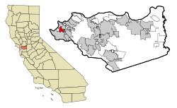
 Location in Contra Costa County and the state of California |
||
| Location in the United States | ||
| Coordinates: 37°57′44″N 122°20′44″W / 37.96222°N 122.34556°WCoordinates: 37°57′44″N 122°20′44″W / 37.96222°N 122.34556°W | ||
| Country |
|
|
| State |
|
|
| County | Contra Costa | |
| Incorporated | April 27, 1948 | |
| Government | ||
| • Mayor | Rich Kinney | |
| • County Board | District 1: John Gioia |
|
| • State Senator | Nancy Skinner (D) | |
| • State Assembly | Tony Thurmond (D) | |
| • U. S. Congress | Mark DeSaulnier (D) | |
| Area | ||
| • Total | 2.634 sq mi (6.822 km2) | |
| • Land | 2.634 sq mi (6.822 km2) | |
| • Water | 0 sq mi (0 km2) 0% | |
| Elevation | 52 ft (16 m) | |
| Population (2010) | ||
| • Total | 29,139 | |
| • Density | 11,000/sq mi (4,300/km2) | |
| Time zone | PST (UTC-8) | |
| • Summer (DST) | PDT (UTC-7) | |
| ZIP code | 94806 | |
| Area code(s) | 510 | |
| FIPS code | 06-68294 | |
| GNIS feature IDs | 1659586, 2411801 | |
| Website | www |
|
San Pablo is a city in Contra Costa County, California, United States. The city of Richmond surrounds nearly the whole city. The population was 29,139 at the 2010 census. The current Mayor is Rich Kinney, and the current Vice Mayor is Paul V. Morris. Current Council members include Cecilia Valdez, Kathy Chao Rothberg, and Rich Kinney.
The area in which today's San Pablo is situated was originally occupied by the Cuchiyun band of the Ohlone indigenous people. The area was claimed for the king of Spain in the late 18th century and was granted for grazing purposes to the Mission Dolores located in today's San Francisco. Upon Mexico's independence from Spain, church properties were secularized and in 1823, the area became part of a large grant to an ex-soldier stationed at the San Francisco Presidio, Francisco María Castro. The grant was given the name Rancho San Pablo, thus originating the name for today's city as well as for one of the East Bay's oldest principal roads, today's San Pablo Avenue (called in the prior Spanish era "El Camino Real de la Contra Costa").
A historic reproduction of the city's Mexican era is designated as a California State Landmark (No.512): the Alvarado Adobe, originally constructed in 1842 by one of Francisco Castro's sons, Jesús María Castro, for his mother, Gabriéla Berryessa de Castro. Upon Gabriéla's death in 1851, it was inherited by her daughter, Martina Castro de Alvarado, wife of Juan Bautista Alvarado, who was Governor of California from 1836 to 1842. The Alvarado Adobe was demolished in the mid-20th century to make way for a motel. A reproduction was built later in the century which is located in the San Pablo Civic Center on the northwest corner of San Pablo Avenue and Church Lane. A single beam from the original structure is incorporated into the roof of the replacement structure, at the rear of the adobe facing the interior courtyard.
...
Wikipedia


