San Mateo–Hayward Bridge
| San Mateo–Hayward Bridge | |
|---|---|

Aerial view of the San Mateo–Hayward Bridge, with Foster City in the foreground
|
|
| Coordinates | 37°36′07″N 122°12′17″W / 37.6019°N 122.2047°WCoordinates: 37°36′07″N 122°12′17″W / 37.6019°N 122.2047°W |
| Carries | Cars and trucks on 6 lanes of |
| Crosses | San Francisco Bay |
| Locale | Foster City and Hayward, California, U.S. |
| Other name(s) | San Mateo Bridge |
| Owner | Caltrans |
| Maintained by | Caltrans and the Bay Area Toll Authority |
| ID number | 35 0054 |
| Characteristics | |
| Design |
|
| Total length |
|
| Width | 41 metres (135 ft) roadway approach |
| Longest span | 757.2 feet (230.8 m) |
| No. of spans |
|
| Clearance below | 134.5 feet (41.0 m) |
| History | |
| Designer | Caltrans, Bay Toll Crossings Division |
| Constructed by |
|
| Fabrication by | Murphy Pacific Corporation, Emeryville |
| Construction cost | US$70,000,000 (equivalent to $503,000,000 in 2016) |
| Opened |
|
| Statistics | |
| Daily traffic | 93,000 |
| Toll | Cars (westbound only) $5.00 (cash or FasTrak), $2.50 (carpools during peak hours, FasTrak only) |

San Francisco Bay Bridges
|
|
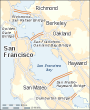
The San Mateo–Hayward Bridge (commonly called the San Mateo Bridge) is a bridge crossing the U.S. state of California's San Francisco Bay, linking the San Francisco Peninsula with the East Bay. The bridge's west end is in Foster City, a suburb on the eastern edge of San Mateo. The east end of the bridge is in Hayward. It is the longest bridge in California and the 25th longest in the world by length. The bridge is owned by the state of California, and is maintained by Caltrans, the state highway agency. Further oversight is provided by the Bay Area Toll Authority.
The bridge is part of State Route 92, whose western terminus is at the town of Half Moon Bay on the Pacific coast. It links Interstate 880 in the East Bay with U.S. Route 101 on the Peninsula. It is roughly parallel to and lies between the San Francisco–Oakland Bay Bridge and the Dumbarton Bridge, and is sometimes used by commuters to avoid traffic delays due to emergencies on those bridges.
The San Francisco Bay Toll-Bridge Company issued US$4,500,000 (equivalent to $62,000,000 in 2016) in bonds to raise a portion of the estimated US$7,500,000 (equivalent to $103,400,000 in 2016) budget required to build the first bridge. First-year operating revenues were anticipated to be US$868,469 (equivalent to $11,974,000 in 2016), but the original bridge lost money in its first year of operation.
...
Wikipedia
