Dumbarton Bridge (California)
| Dumbarton Bridge | |
|---|---|

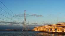
The Dumbarton Bridge and its adjacent powerline towers
|
|
| Coordinates | 37°30′25″N 122°07′01″W / 37.5069°N 122.1169°WCoordinates: 37°30′25″N 122°07′01″W / 37.5069°N 122.1169°W |
| Carries | 6 lanes of |
| Crosses | San Francisco Bay |
| Locale | Menlo Park, California and Fremont, California |
| Owner | Caltrans |
| Maintained by | Caltrans and the Bay Area Toll Authority |
| Characteristics | |
| Design | Twin Concrete Girder Bridge |
| Total length | 2,621.28 meters (8,600.0 feet), 1.63 miles |
| Longest span | 103.63 meters (340.0 feet) |
| Clearance below | 25.91 meters (85.0 feet) (main span) |
| History | |
| Opened | October 1982 |
| Statistics | |
| Daily traffic | 81,000 |
| Toll | Cars (westbound only) $5.00 (cash or FasTrak), $2.50 (carpools during peak hours, FasTrak only) |

Dumbarton Bridge crosses the Southern portion of San Francisco Bay
|
|
The Dumbarton Bridge is the southernmost of the highway bridges across San Francisco Bay in California. Carrying over 81,000 vehicles daily, it is the shortest bridge across San Francisco Bay at 1.63 miles (8,600 ft; 2,620 m). Its eastern end is in Fremont, near Newark in the San Francisco Bay National Wildlife Refuge, and its western end is in Menlo Park. Bridging State Route 84 across the bay, it has three lanes each way and a separated bike/pedestrian lane along its south side. Like the San Mateo Bridge to the north, power lines parallel the bridge.
Tolls are only collected from westbound traffic at the toll plaza on the east side of the bay. Since July 2010, the toll rate for passenger cars is $5. For vehicles with more than two axles, the toll rate is $5 per axle. Drivers may either pay by cash or use the FasTrak electronic toll collection device. There are seven toll lanes at the plaza. During peak traffic hours, the leftmost lane is designated an HOV lane, allowing carpool vehicles carrying two or more people or motorcycles to pass for a toll of $2.50. The next two leftmost lanes are FasTrak-only lanes, and all other lanes accept both cash and FasTrak. During non-peak hours the HOV lane becomes a FasTrak-only lane.
When the current bridge was planned in the 1970s, Caltrans conducted extensive environmental research on the aquatic and terrestrial environment. Principal concerns of the public were air pollution and noise pollution impacts, particularly in some residential areas of Menlo Park and East Palo Alto. Studies were conducted to produce contour maps of projected sound levels and carbon monoxide concentrations throughout the western approaches, for each alternative connection scheme.
...
Wikipedia
