San Luis Potosí (state)
|
San Luis Potosí Estado Libre y Soberano de San Luis Potosí |
|||
|---|---|---|---|
| State | |||
| Free and Sovereign State of San Luis Potosí | |||
|
|||
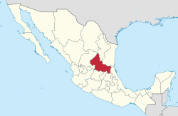
 State of San Luis Potosí within Mexico |
|||
| Coordinates: 22°36′N 100°26′W / 22.600°N 100.433°WCoordinates: 22°36′N 100°26′W / 22.600°N 100.433°W | |||
| Country | Mexico | ||
| Capital | San Luis Potosí | ||
| Largest City | San Luis Potosí | ||
| Municipalities | 58 | ||
| Admission | December 22, 1823 | ||
| Order | 6th | ||
| Government | |||
| • Governor |
Juan Manuel Carreras López |
||
| Area | |||
| • Total | 61,137 km2 (23,605 sq mi) | ||
| Ranked 15th | |||
| Highest elevation | 3,180 m (10,430 ft) | ||
| Population (2015) | |||
| • Total | 2,717,820 | ||
| • Rank | 19th | ||
| • Density | 44/km2 (120/sq mi) | ||
| • Density rank | 20th | ||
| Demonym(s) | Potosino (a) | ||
| Time zone | CST (UTC−6) | ||
| • Summer (DST) | CDT (UTC−5) | ||
| Postal code | 78-79 | ||
| Area code | |||
| ISO 3166 code | MX-SLP | ||
| HDI |
|
||
| GDP | US$ 22,825,212.99 th | ||
| Website | Official Web Site | ||
| ^ a. The state's GDP was $281,040,000 thousand of pesos in 2012, amount corresponding to $22,825,212.99 thousand of dollars, being a dollar worth 12.32 pesos (value of May 21, 2012). | |||
San Luis Potosí (Spanish pronunciation: [san ˈlwis potoˈsi]), officially the Free and Sovereign State of San Luis Potosí (Spanish: Estado Libre y Soberano de San Luis Potosí), is one of the 31 states which, with the Federal District, comprise the 32 Federal Entities of Mexico. It is divided in 58 municipalities and its capital city is San Luis Potosí City.
It is located in North-Central Mexico. It is bordered by 8 other Mexican states, making it the state with the most borders with other neighboring states. The northern borders are with Nuevo León and Coahuila; the northeastern ones with Tamaulipas; the eastern ones with Veracruz; the southern ones with Hidalgo, Querétaro, and Guanajuato; and the northwestern one with Zacatecas.
In addition to the capital city, the state's largest cities include Ciudad Valles, Matehuala, Rioverde, and Tamazunchale.
In pre-Columbian times the territory now occupied by the state of San Luis Potosí contained the cultural areas of Mesoamerica and Aridoamerica. Its northern and western-central areas were inhabited by the Otomi and Chichimeca tribes. These indigenous groups were nomadic hunter-gatherers. Although most natives died during the Spanish settlements, huasteco groups still live, along with pame and náhuatl although their numbers are significantly small.
...
Wikipedia


