San'in Region
|
San'in region 山陰地方 |
|
|---|---|
| Region | |

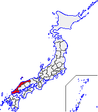
Map of the San'in Region
|
|
| Area | |
| • Total | 11,680.73 km2 (4,509.96 sq mi) |
| Population (June 1, 2009) | |
| • Total | 1,416,011 |
| • Density | 120/km2 (310/sq mi) |
| Time zone | JST (UTC+9) |
The San'in Region (山陰地方 San'in Chihō?) is an area in the southwest of Honshū, the main island of Japan. It consists of the northern part of the Chūgoku region, facing the Sea of Japan.
The name San'in in the Japanese language is formed from two kanji characters. The first, , "mountain", and the second, represents the "yin" of yin and yang. The name means the northern, shady side of the mountains in contrast to the yang "southern, sunny" San'yō region to the south.
The San'in region has numerous Paleolithic and Jōmon period (14,000 – 300 BC) remains, but its Yayoi period (300 BC – 250 AD) remains are the largest in Japan. The Mukibanda Yayoi remains in the low foothills of Mount Daisen in the cities of Daisen and Yonago, Tottori Prefecture are the largest in Japan. The site is still only partially unexcavated, but indicates that the San'in was a regional center of power in the period. The mythology of the Shinto religion is largely based in the Izumo area of the region, and the Izumo-taisha, or Izumo Grand Shrine in Izumo, Shimane Prefecture, is one of the most ancient and important Shinto shrines in Japan. The eastern part of Shimane Prefecture also had cultural and economic connections to the Asian mainland from an early period.
...
Wikipedia
