Saltlick Township, Fayette County, Pennsylvania
| Saltlick Township | |
|---|---|
| Township | |

Saltlick Township Volunteer Fire Company
|
|
| Etymology: "Salt lick" | |
 Location of Saltick Township in Fayette County |
|
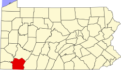
 Location of Fayette County in Pennsylvania |
|
| Country | United States |
| State | Pennsylvania |
| County | Fayette |
| Area | |
| • Total | 37.63 sq mi (97.47 km2) |
| • Land | 37.63 sq mi (97.46 km2) |
| • Water | 0.004 sq mi (0.01 km2) |
| Population (2010) | |
| • Total | 1,659 |
| • Estimate (2016) | 3,372 |
| • Density | 92/sq mi (35.5/km2) |
| Time zone | EST (UTC-4) |
| • Summer (DST) | EDT (UTC-5) |
| Area code(s) | 724 |
| Website | saltlicktownship |
Saltlick Township is a township in Fayette County, Pennsylvania, United States. The population was 3,461 at the 2010 census, down from 3,715 at the 2000 census. It is served by the Connellsville Area School District.
Indian Head, Millertown, Champion, Maple Grove, White, Clinton, and Melcroft are unincorporated communities in the township.
Saltlick Township occupies the northeast corner of Fayette County, with Westmoreland County to the north and Somerset County to the east. Pennsylvania Routes 381 and 711 cross the center of the township following the Indian Creek valley. The western side of the township sits on the crest of Chestnut Ridge, while the eastern side is on the parallel and higher Laurel Hill.
According to the United States Census Bureau, the township has a total area of 37.6 square miles (97.5 km2), of which 0.004 square miles (0.01 km2), or 0.01%, is water.
As of the census of 2000, there were 3,715 people, 1,385 households, and 1,052 families residing in the township. The population density was 98.7 people per square mile (38.1/km²). There were 1,743 housing units at an average density of 46.3/sq mi (17.9/km²). The racial makeup of the township was 99.33% White, 0.03% Native American, 0.08% Asian, and 0.57% from two or more races. Hispanic or Latino of any race were 0.38% of the population.
...
Wikipedia
