Sainte-Thècle, Quebec
| Sainte-Thècle | |
|---|---|
| Municipality | |
 |
|
| Motto: Scatter goodness along your path | |
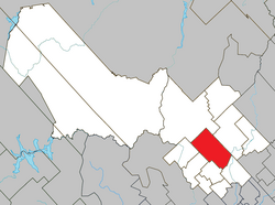
 Location within Mékinac RCM. |
|
| Location in central Quebec. | |
| Coordinates: 46°49′N 72°30′W / 46.817°N 72.500°WCoordinates: 46°49′N 72°30′W / 46.817°N 72.500°W | |
| Country |
|
| Province |
|
| Region | Mauricie |
| RCM | Mékinac |
| Watershed | Batiscan River |
| Constituted | June 7, 1989 |
| Government | |
| • Mayor | Alain Vallée |
| • Federal riding | Saint-Maurice—Champlain |
| • Prov. riding | Laviolette |
| Area | |
| • Municipality | 221.60 km2 (85.56 sq mi) |
| • Land | 213.46 km2 (82.42 sq mi) |
| • Urban | 2.25 km2 (0.87 sq mi) |
| Population (2011) | |
| • Municipality | 2,478 |
| • Density | 11.6/km2 (30/sq mi) |
| • Urban | 1,296 |
| • Urban density | 580/km2 (1,500/sq mi) |
| • Pop 2006-2011 |
|
| • Dwellings | 1,413 |
| Time zone | EST (UTC−5) |
| • Summer (DST) | EDT (UTC−4) |
| Postal code(s) | G0X 3G0 |
| Area code(s) | 418 and 581 |
| Highways |
|
| Website | www |
Sainte-Thècle is a Canadian municipality located in the province of Quebec in the Mékinac Regional County Municipality, in the watershed Batiscanie and in the administrative region of Mauricie. This municipality of 216 square km is particularly known for its resorts around the 55 lakes that dot the area. The forest and mountain scenery offer exceptional views for tourists and vacationers. Sainte-Thècle is also a paradise for hunting, fishing, snowmobile/all-terrain vehicles and other outdoor sports. The church, rectory and cemetery, located on the dominant hill of the village is a heritage of great interest. The agricultural and forestry industries have marked its history.
Sainte-Thècle is located at the junction of provincial roads 153 and 352. Road 153, running north-south links Yamachiche to Lac-aux-Sables, via Saint-Tite. On his way to Sainte-Thècle, route 153 covers the path of the great rang St-Georges, Notre-Dame street, St-Jacques street and road St-Pierre-North. While the route 352 from Trois-Rivières, pass through Saint-Stanislas and Saint-Adelphe and then arrives at Sainte-Thècle, on the path of road Rompré, then road St-Thomas, ending at the intersection of road 153 in the village of Sainte-Thècle.
The municipality of Sainte-Thècle is enclosed by Saint-Tite (south), Grandes-Piles (south-west), Saint-Roch-de-Mékinac (south-west), Trois-Rives (north) Lac-aux-Sables (north) and Saint-Adelphe (southeast). Almost all the territory of Sainte-Thècle is part of the watershed of Batiscan River, except an area at the north-east (the limit of Trois-Rives) and another small area near the Missionary Lake at northeast.
...
Wikipedia

