Saint Paul (city)
| Saint Paul, Minnesota | |||
|---|---|---|---|
| State capital | |||
| City of Saint Paul | |||

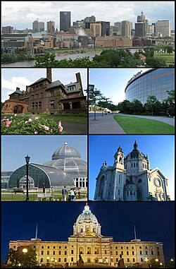
Clockwise from the top: Downtown Saint Paul as seen from Harriet Island, the Xcel Energy Center, the Saint Paul Cathedral, the Minnesota State Capitol, the Marjorie McNeely Conservatory, and the historic James J. Hill House
|
|||
|
|||
| Nickname(s): "the Capital City", "the Saintly City", "Pig's Eye", "STP", "Last City of the East" | |||
| Motto: The most livable city in America.1 | |||
 Location in Ramsey County and the state of Minnesota |
|||
| Location in Minnesota, United States & North America | |||
| Coordinates: 44°56′39″N 93°5′37″W / 44.94417°N 93.09361°WCoordinates: 44°56′39″N 93°5′37″W / 44.94417°N 93.09361°W | |||
| Country | United States | ||
| State | Minnesota | ||
| County | Ramsey | ||
| Incorporated | March 4, 1854 | ||
| Named for | St. Paul the Apostle | ||
| Government | |||
| • Mayor | Chris Coleman (DFL) | ||
| Area | |||
| • City | 56.18 sq mi (145.51 km2) | ||
| • Land | 51.98 sq mi (134.63 km2) | ||
| • Water | 4.20 sq mi (10.88 km2) | ||
| Elevation | 702 ft (214 m) | ||
| Population (2010) | |||
| • City | 285,068 | ||
| • Estimate (2016) | 302,398 | ||
| • Rank | City: 64th MN: 2nd | ||
| • Density | 5,818/sq mi (2,246/km2) | ||
| • Metro | 3,524,583 (US: 16th) | ||
| • Demonym | Saint Paulite | ||
| Time zone | CST (UTC-6) | ||
| • Summer (DST) | CDT (UTC-5) | ||
| ZIP codes | 55101–55175 | ||
| Area code(s) | 651 | ||
| Website | www.stpaul.gov | ||
| 1 Current as of July 30, 2008. | |||
Saint Paul (/ˌseɪnt ˈpɔːl/; abbreviated St. Paul) is the capital and second-most populous city of the U.S. state of Minnesota. As of 2016, the city's estimated population was 304,442. Saint Paul is the county seat of Ramsey County, the smallest and most densely populated county in Minnesota. The city lies mostly on the east bank of the Mississippi River in the area surrounding its point of confluence with the Minnesota River, and adjoins Minneapolis, the state's largest city. Known as the "Twin Cities", the two form the core of Minneapolis–Saint Paul, the 16th-largest metropolitan area in the United States, with about 3.52 million residents.
Founded near historic Native American settlements as a trading and transportation center, the city rose to prominence when it was named the capital of the Minnesota Territory in 1849. The Dakota name for Saint Paul is "Imnizaska". Though Minneapolis (Bdeota) is better-known nationally, Saint Paul contains the state government and other important institutions. Regionally, the city is known for the Xcel Energy Center, home of the Minnesota Wild, and for the Science Museum of Minnesota. As a business hub of the Upper Midwest, it is the headquarters of companies such as Ecolab. Saint Paul, along with its Twin City, Minneapolis, is known for its high literacy rate. It was the only city in the United States with a population of 250,000 or more to see an increase in circulation of Sunday newspapers in 2007.
...
Wikipedia


