Saint Francis County, Arkansas
| Saint Francis County, Arkansas | |
|---|---|

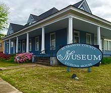
St. Francis County Museum in Forrest City, Arkansas.
|
|
 Location in the U.S. state of Arkansas |
|
 Arkansas's location in the U.S. |
|
| Founded | October 13, 1827 |
| Named for | St. Francis River |
| Seat | Forrest City |
| Largest city | Forrest City |
| Area | |
| • Total | 643 sq mi (1,665 km2) |
| • Land | 635 sq mi (1,645 km2) |
| • Water | 7.7 sq mi (20 km2), 1.2% |
| Population (est.) | |
| • (2016) | 26,196 |
| • Density | 45/sq mi (17/km²) |
| Congressional district | 1st |
| Time zone | Central: UTC-6/-5 |
St. Francis County is a county located in the U.S. state of Arkansas. As of the 2010 census, the population was 28,258. The county seat is Forrest City.
St. Francis County comprises the Forrest City, AR Micropolitan Statistical Area, which is also included in the Memphis-Forrest City, TN-MS-AR Combined Statistical Area.
A portion of St. Francis County is represented in the Arkansas State Senate by the Republican Ronald R. Caldwell
The county was formed on October 13, 1827, and named for the St. Francis River.
According to the U.S. Census Bureau, the county has a total area of 643 square miles (1,670 km2), of which 635 square miles (1,640 km2) is land and 7.7 square miles (20 km2) (1.2%) is water.
As of the 2010 census, there were 28,258 people residing in the county. 51.9% were Black or African American, 44.2% White, 0.5% Native American, 0.5% Asian, 1.4% of some other race and 1.5% of two or more races. 4.1% were Hispanic or Latino (of any race).
...
Wikipedia
