Saint-Herblain
| Saint-Herblain | ||
|---|---|---|

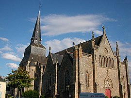
The church of Saint-Hermeland, in Saint-Herblain
|
||
|
||
| Coordinates: 47°12′44″N 1°38′59″W / 47.2122°N 1.6497°WCoordinates: 47°12′44″N 1°38′59″W / 47.2122°N 1.6497°W | ||
| Country | France | |
| Region | Pays de la Loire | |
| Department | Loire-Atlantique | |
| Arrondissement | Nantes | |
| Canton | Saint-Herblain-Est, Saint-Herblain-Ouest-Indre | |
| Intercommunality | Urban Community of Nantes | |
| Government | ||
| • Mayor (2014–2020) | Bertrand Affilé | |
| Area1 | 30.02 km2 (11.59 sq mi) | |
| Population (1999)2 | 43,726 | |
| • Density | 1,500/km2 (3,800/sq mi) | |
| Time zone | CET (UTC+1) | |
| • Summer (DST) | CEST (UTC+2) | |
| INSEE/Postal code | 44162 / 44800 | |
| Elevation | 1–64 m (3.3–210.0 ft) | |
|
1 French Land Register data, which excludes lakes, ponds, glaciers > 1 km² (0.386 sq mi or 247 acres) and river estuaries. 2Population without double counting: residents of multiple communes (e.g., students and military personnel) only counted once. |
||
1 French Land Register data, which excludes lakes, ponds, glaciers > 1 km² (0.386 sq mi or 247 acres) and river estuaries.
Saint-Herblain (Breton: Sant-Ervlan) is a commune in the Loire-Atlantique department in western France.
It is the largest suburb of the city of Nantes, and lies adjacent to its west side.
In 2008, 0,36% of the children attended the bilingual schools in primary education. The school network in Breton Diwan has opened a college in Saint-Herblain, the first in the area.
The Gare de Basse-Indre-Saint-Herblain railway station is served by regional trains between Nantes and Saint-Nazaire.
Saint-Herblain has town twinning and cooperation agreements with:
...
Wikipedia


