Saint-Edouard, Quebec
| Saint-Édouard | |
|---|---|
| Municipality | |
 |
|
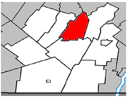
 Location within Les Jardins-de-Napierville RCM. |
|
| Location in southern Quebec. | |
| Coordinates: 45°14′N 73°31′W / 45.233°N 73.517°WCoordinates: 45°14′N 73°31′W / 45.233°N 73.517°W | |
| Country |
|
| Province |
|
| Region | Montérégie |
| RCM | Les Jardins-de-Napierville |
| Constituted | July 1, 1855 |
| Government | |
| • Mayor | Michel Raymond |
| • Federal riding | Beauharnois—Salaberry |
| • Prov. riding | Huntingdon |
| Area | |
| • Total | 52.70 km2 (20.35 sq mi) |
| • Land | 52.93 km2 (20.44 sq mi) |
| There is an apparent contradiction between two authoritative sources |
|
| Population (2011) | |
| • Total | 1,312 |
| • Density | 24.8/km2 (64/sq mi) |
| • Pop 2006-2011 |
|
| • Dwellings | 536 |
| Time zone | EST (UTC−5) |
| • Summer (DST) | EDT (UTC−4) |
| Postal code(s) | J0L 1Y0 |
| Area code(s) | 450 and 579 |
| Highways |
|
Saint-Édouard is a municipality in the Jardins de Napierville Regional County Municipality in Quebec, Canada, situated in the Montérégie administrative region. The population as of the Canada 2011 Census was 1,312.
...
Wikipedia

