Saint-Die
| Saint-Dié-des-Vosges | ||
|---|---|---|

Cathedral
|
||
|
||
| Coordinates: 48°17′N 6°57′E / 48.28°N 6.95°ECoordinates: 48°17′N 6°57′E / 48.28°N 6.95°E | ||
| Country | France | |
| Region | Grand Est | |
| Department | Vosges | |
| Arrondissement | Saint-Dié-des-Vosges | |
| Intercommunality | CA Saint-Dié-des-Vosges | |
| Government | ||
| • Mayor | David Valence | |
| Area1 | 46.15 km2 (17.82 sq mi) | |
| Population (2011)2 | 21,361 | |
| • Density | 460/km2 (1,200/sq mi) | |
| Time zone | CET (UTC+1) | |
| • Summer (DST) | CEST (UTC+2) | |
| INSEE/Postal code | 88413 /88100 | |
| Elevation | 310–901 m (1,017–2,956 ft) (avg. 343 m or 1,125 ft) |
|
|
1 French Land Register data, which excludes lakes, ponds, glaciers > 1 km² (0.386 sq mi or 247 acres) and river estuaries. 2Population without double counting: residents of multiple communes (e.g., students and military personnel) only counted once. |
||
1 French Land Register data, which excludes lakes, ponds, glaciers > 1 km² (0.386 sq mi or 247 acres) and river estuaries.
Saint-Dié-des-Vosges (French pronunciation: [sɛ̃.dje.de.voʒ]), commonly referred to as Saint-Dié, is a commune in the Vosges department in Grand Est in northeastern France.
It is a sub-prefecture of the department.
Saint-Dié is located in the Vosges Mountains 80 km (50 mi) southeast of Nancy and 45 km (28 mi) of Lunéville. This route in the valley of Meurthe was always the more frequented, and first to get a rail line in 1864, so now it accommodates the primary road.
Saint-Dié-des-Vosges, principal town of an arrondissement of the same name, belongs to the Vosges département of France. This commune with a little town in her center, is approximately 50 km (31 mi) northeast of Épinal, and connected by two roads, south through the passes of Haut-Jacques and Bruyères or north by the pass of Haut-du-Bois and the ancient land of Rambervillers. By rail, Épinal is 61 km (38 mi)] from Saint-Dié.
The river Meurthe flows in the Permian basin of Saint-Dié surrounded by wooded mountains, Ormont, Kemberg and La Madeleine. The peaks of these mountains are 550 metres (1,800 feet) high, and are composed of Triassic formations, especially the so-called "Vosges sandstone", a kind of red sandstone.
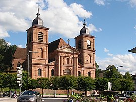
The town was nearly completely redesigned and rebuilt in the French Uniform Style after the fire of 1757. A major part was destroyed in November, 1944 and was rebuilt largely in a material imitating red sandstone. Its cathedral has a Gothic nave and choir designed in the 14th century; the portal of red stone was created by Giovanni Betto in the beginning of the 18th century. A cloister, begun in the 14th century but never finished, contains a stone pulpit, and connects with the Petite-Eglise or Notre-Dame-de-Galilée, a well-preserved specimen of Romanesque architecture of the 12th century. All of the monuments were restored or rebuilt in the same manner after 1950.
...
Wikipedia


