Sagay City
| Sagay | ||
|---|---|---|
| Component City | ||
| City of Sagay | ||
|
||
| Nickname(s): Garden City of the North | ||
| Motto: Land of Hope and Progress | ||
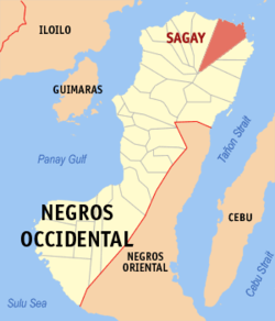
 Map of Negros Occidental with Sagay highlighted |
||
| Location within the Philippines | ||
| Coordinates: 10°54′N 123°25′E / 10.900°N 123.417°ECoordinates: 10°54′N 123°25′E / 10.900°N 123.417°E | ||
| Country | Philippines | |
| Region | Negros Island Region (NIR/Region XVIII) | |
| Province | Negros Occidental | |
| District | 2nd district of Negros Occidental | |
| Established | 1860 | |
| Cityhood | August 10, 1996 | |
| Barangays | 25 | |
| Government | ||
| • Mayor | Alfredo D. Marañon III | |
| Area | ||
| • City | 330.34 km2 (127.54 sq mi) | |
| Population (2010) | ||
| • City | 140,740 | |
| • Density | 430/km2 (1,100/sq mi) | |
| Time zone | PST (UTC+8) | |
| ZIP code | 6122 | |
| IDD : area code | 34 | |
| Languages | Hiligaynon, Cebuano, Tagalog, English | |
Sagay, officially Sagay City, is a third class city in the province of Negros Occidental, Philippines. According to the 2010 census, it has a population of 140,740 people.
Sagay can be identified in the map of Negros Occidental because of its "ice-cream cone" shape sliced from the northern tip of Negros. It is bounded in the north by Asuncion Pass and the Visayan Sea; the City of Talisay and Municipality of Calatrava in the south; cities of Cadiz and Silay in the west and the City of Escalante and Municipality of Toboso in the east.
The name of the city comes from the semi-spherical shell called "sigay", which can be found in the area.
Sagay City is politically subdivided into 25 Barangay.
Andres Bonifacio became a barrio in the late 60’s. Formerly known as Sitio Maasin, it was once the biggest sitio of Barrio Vito and contributed a huge income because of its lime quarries and vast land area. The separation of Andres Bonifacio from Vito was materialized through land donation of the barrio and school sites by the family of the late Carlos and Elea Canoy-Esperancilla. It was Mrs. Elea Canoy Esperancilla who suggested to name the new barrio Andres Bonifacio to give honor to the great Filipino hero. Today, Andres Bonifacio is a fast moving barangay when it comes to development and progress. It is also noted for its natural and man-made caves
Sometime in 1929, Bato, then a forestall land with few inhabitants was a place of gathering of people living in the hinterlands. There used to be a place called “tabu”, where people from the hinterlands meet for recreation like cockfighting (“tari”) or horse fighting in a clearing area near the Himoga-an River where a big rock (“bato”) was a landmark. The place was also used by the people during “tabu”, a day set by them for marketing or bartering their products. For the few residents of the place, this clearing also served as a place of recreation. For people who visited the place for recreation or for economic reasons, they named the place Bato because of the big rock.
...
Wikipedia


