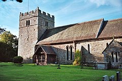
Rushbury
| Rushbury | |
|---|---|
 St Peter's parish church, Rushbury |
|
| Rushbury shown within Shropshire | |
| Population | 699 (2011) |
| OS grid reference | SO513918 |
| Civil parish |
|
| Unitary authority | |
| Ceremonial county | |
| Region | |
| Country | England |
| Sovereign state | United Kingdom |
| Post town | CHURCH STRETTON |
| Postcode district | SY6 |
| Dialling code | 01694 |
| Police | West Mercia |
| Fire | Shropshire |
| Ambulance | West Midlands |
| EU Parliament | West Midlands |
| UK Parliament | |
Rushbury is a village and civil parish in Shropshire, roughly five miles from Church Stretton and eight miles from Much Wenlock.
Nearby villages include Cardington, Longville in the Dale, Ticklerton and Wall under Haywood. Longville and Wall lie within Rushbury parish.
Rushbury is a quiet rural community, with a Church of England church and primary school.
The name Rushbury is thought to derive from Rush Manor, but other evidence suggests that it could originate from the Old English 'risc', literally meaning 'a place where rushes grow', and the Old English word 'burh', meaning a 'fortified place'; putting the two together gives 'Rush Fortification'. Human activity has been present since Neolithic times and there was once an Iron Age hill fort. The area of Rushbury Civil Parish (CP) has changed throughout history. According to the 1831 census it was 5,620 acres, before decreasing to 4,132 acres by the 1851 census and then increasing to 6,304 by 1891, where it has remained ever since. Rushbury CP now includes the settlements of East Wall, Longville in the Dale, Lushcott, Stanway, Stone Acton and Wall under Heywood.
Throughout history the population has changed; from the start of the census in 1801 the population steadily increased and reached a peak of 507 in 1831, after which it decreased slightly to 495 before increasing again (with the exception of 1921 where it was 530) in 1881 from 500. There was a slight decrease again in 1951.see chart on population of Rushbury. According to the 2001 census the population was 603.
According to the Domesday book Rushbury had the most arable land compared to the surrounding manors. In 1086 it had: "two ploughteams in demesne worked by 4 servi, while 1 villanus, 2 bordars, and 3 radmen worked five more". Rushbury also had enough woodland in the Middle Ages to fatten 40 swine and about 1250, one pig in ten was given to the lord of Lutwyche. However, by 1301 most of Rushbury had deforested and been made warren land. In 1086 one water mill was recorded at Rushbury and a tanner was supposed to have lived here in 1602. A link showing a pie chart of occupational categories in 1831 here. Over three quarters of the male population aged over 20 were involved in agriculture see chart. A map showing land utilisation of Rushbury in 1942 can be seen here. The yellow areas represent common land, brown arable land, dark green mixed forest and purple houses with gardens, allotments and orchards.
...
Wikipedia

