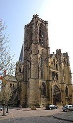
Rufach
| Rouffach | ||
|---|---|---|
| Commune | ||
 |
||
|
||
| Coordinates: 47°57′30″N 7°17′54″E / 47.9583°N 7.2983°ECoordinates: 47°57′30″N 7°17′54″E / 47.9583°N 7.2983°E | ||
| Country | France | |
| Region | Grand Est | |
| Department | Haut-Rhin | |
| Arrondissement | Thann-Guebwiller | |
| Canton | Wintzenheim | |
| Intercommunality | Pays de Rouffach | |
| Government | ||
| • Mayor (2008–2014) | Jean-Pierre Toucas | |
| Area1 | 40.05 km2 (15.46 sq mi) | |
| Population (2006)2 | 4,865 | |
| • Density | 120/km2 (310/sq mi) | |
| Time zone | CET (UTC+1) | |
| • Summer (DST) | CEST (UTC+2) | |
| INSEE/Postal code | 68287 /68250 | |
| Elevation | 195–980 m (640–3,215 ft) (avg. 210 m or 690 ft) |
|
|
1 French Land Register data, which excludes lakes, ponds, glaciers > 1 km² (0.386 sq mi or 247 acres) and river estuaries. 2Population without double counting: residents of multiple communes (e.g., students and military personnel) only counted once. |
||
1 French Land Register data, which excludes lakes, ponds, glaciers > 1 km² (0.386 sq mi or 247 acres) and river estuaries.
Rouffach (German and Alsatian: Rufach) is a commune in the Haut-Rhin department in Grand Est in north-eastern France.
Rouffach lies along the Alsatian wine route (Route des Vins d'Alsace). Its vineyards produce one of the finest Alsatian wines: the Grand Cru Vorbourg.
Rouffach is situated on the Lauch River, 15 km (9.3 mi) south of Colmar and 28 km (17 mi) north of Mulhouse, on the vineyards of the eastern foothills of the Vosges Mountains. The most important transportation routes between the towns are the N83 (Lyon–Strasbourg) and the railway line Strasbourg-Mulhouse-Basel.
in pago qui vocatur Rubiaco (charter, 662), Rubiacum 12th century, Rufiacum 13th century. In records of the diocese of Strasbourg it is called Upper Mundat.
The name derives from the Gallo-Roman male's name Rubbius or Rubius ending with Celtic suffix -āko > (cf. Welsh -og).
Similar place-names in France : Royat (Rubiacum 1147), Robiac (Robiaco 1119).
In the 5th century, the walled village (oppidum) beneath the stronghold of Isenburg was a residence of the Merovingian kings. According to pious legend recorded in the chronicle of Ebersmunster, the son of King Dagobert II gave the city to Arbogast, bishop of Strasbourg, in the 7th century, after the bishop had re-awakened his son Sigebert from death in a hunting incident. More certainly the fief was one of the most ancient belonging to Strasbourg. It finally became the main town of an episocopal fief, which also included Eguisheim. The city quickly developed and a wall was built around it.
...
Wikipedia


