Royal Chitwan National Park
| Chitwan National Park | |
|---|---|
|
IUCN category II (national park)
|
|

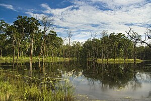
Bishazari Tal in Chitwan National Park
|
|

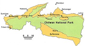
Map of Chitwan National Park
|
|
| Location | Nepal |
| Nearest city | Bharatpur |
| Coordinates | 27°30′0″N 84°20′0″E / 27.50000°N 84.33333°ECoordinates: 27°30′0″N 84°20′0″E / 27.50000°N 84.33333°E |
| Area | 932 km2 (360 sq mi) |
| Established | 1973 |
| Type | Natural |
| Criteria | vii, ix, x |
| Designated | 1984 (8th session) |
| Reference no. | 284 |
| State Party |
|
| Region | Asia |
Chitwan National Park (Nepali: चितवन राष्ट्रिय निकुञ्ज; formerly Royal Chitwan National Park) is the first national park in Nepal. It was established in 1973 and granted the status of a World Heritage Site in 1984. It covers an area of 932 km2 (360 sq mi) and is located in the subtropical Inner Terai lowlands of south-central Nepal in the districts of Nawalparasi, Parsa, Chitwan and Makwanpur. In altitude it ranges from about 100 m (330 ft) in the river valleys to 815 m (2,674 ft) in the Churia Hills.
In the north and west of the protected area the Narayani-Rapti river system forms a natural boundary to human settlements. Adjacent to the east of Chitwan National Park is Parsa Wildlife Reserve, contiguous in the south is the Indian Tiger Reserve Valmiki National Park. The coherent protected area of 2,075 km2 (801 sq mi) represents the Tiger Conservation Unit (TCU) Chitwan-Parsa-Valmiki, which covers a 3,549 km2 (1,370 sq mi) huge block of alluvial grasslands and subtropical moist deciduous forests.
Since the end of the 19th century Chitwan – Heart of the Jungle – used to be a favorite hunting ground for Nepal’s ruling class during the cool winter seasons. Until the 1950s, the journey from Kathmandu to Nepal’s south was arduous as the area could only be reached by foot and took several weeks. Comfortable camps were set up for the feudal big game hunters and their entourage, where they stayed for a couple of months shooting hundreds of tigers, rhinocerosses, leopards and sloth bears.
...
Wikipedia
