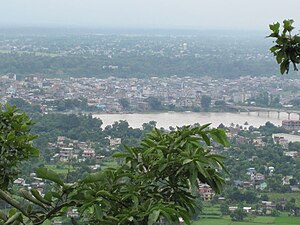
Bharatpur, Nepal
|
Bharatpur Metropolitan City भरतपुर महानगरपालिका |
|
|---|---|
| Metropolitan City | |

Bharatpur city view from Maula Kalika temple Gaindakot
|
|
| Location in Nepal | |
| Coordinates: 27°41′N 84°26′E / 27.683°N 84.433°E | |
| Country |
|
| Zone | Narayani Zone |
| District | Chitwan District |
| Government | |
| • Type | Bharatpur Metropolitan |
| Area | |
| • Total | 433 km2 (167 sq mi) |
| Elevation | 208 m (682 ft) |
| Population (2015)census | |
| • Total | 280,502 |
| • Density | 650/km2 (1,700/sq mi) |
| Time zone | NST (UTC+5:45) |
| Postal code | 44200, 44207(Narayangarh) |
| Area code(s) | 056 |
| Climate | Cwa |
| Website | www |
|
Narayangadh नारायणगढ |
|
|---|---|
| subdivision of Bharatpur | |
| Location in Nepal | |
| Coordinates: 27°44′N 84°23′E / 27.73°N 84.39°E | |
| Country |
|
| Zone | Narayani Zone |
| District | Chitwan District |
| Area | |
| • Total | 554.0 km2 (213.9 sq mi) |
| Population (1991) | |
| • Total | 202,874 |
| • Density | 370/km2 (950/sq mi) |
| Time zone | Nepal Time (UTC+5:45) |
Bharatpur (Nepali: भरतपुर) is a city in the central-southern part of Nepal. Located in Chitwan District, Bharatpur is the district headquarter of the Chitwan District, as well as a separate Metropolitan authority, and is the fifth largest city of Nepal, After Kathmandu, Pokhara and Lalitpur is also a one of the four Metro city of Nepal with the population of 2,80,502 (census 2015). Bharatpur is one of the fast growing cities of Nepal. It lies on the left bank of Narayani River and serves as a commercial centre of Chitwan district and central region of Nepal. It is located at the centre of Mahendra Highway and Kathmandu - Birganj (North-South) road corridor. The proximity of this city from Kathmandu (146 km), Pokhara (126 km), Butwal (114 km), Ghorahi (275 km), Birgunj (128 km), Hetauda (78 km) and Prithivinarayan (Gorkha) (67 km) has augmented the importance of its advantageous geographical location. In addition to good road access, Bharatpur has regular daily air services to Kathmandu and Pokhara.
Most of the shopping area lies in the district of Narayangadh, while government offices, big hospitals and colleges are situated in other parts of the city, including Nepal's premier cancer hospital, B.P Koirala Memorial Cancer Hospital. The economy of Bharatpur was traditionally based on agriculture. The agricultural land is gradually converted into the residential and industrial areas. Main industries of Bharatpur are small scale processing industries. A large number of poultry industries have developed in the municipality. It is believed that it covers more than 60% of the total poultry demand of the country. Moreover, this metropolitan city has a substantial volume of poultry products for export trade. Other products of the city are honey, mushroom, floriculture, and service industry (education and health). Chitwan is regarded as food surplus district, which is processed in Bharatpur and sold to major cities of the country including Kathmandu and Pokhara. Besides, multinational companies like Coca-Cola, San Miguel Beer are also situated within the city. A large number of business and trading houses are based in the city. The major companies across the country have opened their branches in the city. Its central position along with the crossroads of Bharatpur has enabled it to increase its wholesale and retail trading function.
...
Wikipedia


