Narayani River
| Gandaki River (गंडक) | |
| Narayani | |
|
नारायणी नदी (चितवन)
|
|
| Countries | Tibet (China), Nepal, India |
|---|---|
| Tributaries | |
| - left | Trishuli, Budhi Gandaki River, Marshyangdi, Madi, Seti Gandaki River |
| - right | Kali Gandaki River |
| Cities | Lo Manthang, Jomsom, Beni, Kusma, Ridi, Devgat, Narayangarh, Valmikinagar, Triveni, Nepal, Hajipur, Sonpur, Bagaha |
| Source | Nhubine Himal Glacier |
| - location | Mustang, Nepal |
| - elevation | 6,268 m (20,564 ft) |
| - coordinates | 29°17′0″N 85°50′5″E / 29.28333°N 85.83472°E |
| Mouth | Ganges |
| - location | Sonepur, India |
| - elevation | 44 m (144 ft) |
| - coordinates | 25°39′9″N 85°11′4″E / 25.65250°N 85.18444°ECoordinates: 25°39′9″N 85°11′4″E / 25.65250°N 85.18444°E |
| Length | 630 km (391 mi) |
| Basin | 46,300 km2 (17,877 sq mi) |
| Discharge | |
| - average | 1,760 m3/s (62,154 cu ft/s) |
| - max | 30,000 m3/s (1,059,440 cu ft/s) |
| - min | 500 m3/s (17,657 cu ft/s) |
| Chitwan National Park | |
|---|---|
|
IUCN category II (national park)
|
|

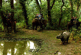
Elephant safari after Indian rhinoceros
|
The Gandaki River (also known as the Narayani in southern Nepal and the Gandak in India) is one of the major rivers of Nepal and a tributary of the Ganges in India. In Nepal the river is notable for its deep gorge through the Himalayas and its enormous hydroelectric potential. It has a total catchment area of 46,300 square kilometers (17,900 sq mi), most of it in Nepal. The basin also contains three of the world's 14 mountains over 8,000 metres (26,000 ft), Dhaulagiri, Manaslu and Annapurna I. Dhaulagiri is the highest point of the Gandaki basin. It lies between the similar Kosi system to the east and the Karnali (Ghaghara) system to the west.
The Kali Gandaki river source is at the border with Tibet at an elevation of 6,268 metres (20,564 ft) at the Nhubine Himal Glacier in the Mustang region of Nepal.
The headwaters stream on some maps is named the Chhuama Khola and then, nearing Lo Manthang, the Nhichung Khola or Choro Khola. The Kali Gandaki then flows southwest (with the name of Mustang Khola on old, outdated maps) through a sheer-sided, deep canyon before widening at the steel footbridge at Chele, where part of its flow funnels through a rock tunnel, and from this point the now wide river is called the Kali Gandaki on all maps. In Kagbeni a major tributary named Johng Khola, Kak Khola or Krishnaa descends from Muktinath.
The river then flows southward through a steep gorge known as the Kali Gandaki Gorge, or Andha Galchi, between the mountains Dhaulagiri, elevation 8,167 metres (26,795 ft) to the west and Annapurna I, elevation 8,091 metres (26,545 ft) to the east. If one measures the depth of a canyon by the difference between the river height and the heights of the highest peaks on either side, this gorge is the world's deepest. The portion of the river directly between Dhaulagiri and Annapurna I, 7 kilometres (4 mi) downstream from Tukuche), is at an elevation of 2,520 metres (8,270 ft), which is 5,571 metres (18,278 ft) lower than Annapurna I. The river is older than the Himalayas. As tectonic activity forces the mountains higher, the river has cut through the uplift.
...
Wikipedia


