Manaslu
| Manaslu | |
|---|---|

Manaslu at sunrise
|
|
| Highest point | |
| Elevation | 8,163 m (26,781 ft) Ranked 8th |
| Prominence | 3,092 m (10,144 ft) Ranked 80th |
| Isolation | 106 kilometres (66 mi) |
| Listing |
Eight-thousander Ultra |
| Coordinates | 28°32′58″N 84°33′43″E / 28.54944°N 84.56194°ECoordinates: 28°32′58″N 84°33′43″E / 28.54944°N 84.56194°E |
| Naming | |
| Translation | Mountain of the spirit (Sanskrit) |
| Geography | |
| Location | Gorkha, Manang-Gandaki Zone, Nepal |
| Parent range | Mansiri Himal, Himalayas |
| Climbing | |
| First ascent | May 9, 1956 by a Japanese team (First winter ascent 12 January 1984 Maciej Berbeka and Ryszard Gajewski) |
| Easiest route | snow/ice climb |
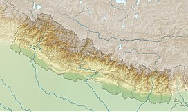
Manaslu (Nepali: मनास्लु, also known as Kutang) is the eighth highest mountain in the world at 8,163 metres (26,781 ft) above sea level. It is located in the Mansiri Himal, part of the Nepalese Himalayas, in the west-central part of Nepal. Its name, which means "mountain of the spirit", comes from the Sanskrit word manasa, meaning "intellect" or "soul". Manaslu was first climbed on May 9, 1956 by Toshio Imanishi and Gyalzen Norbu, members of a Japanese expedition. It is said that "just as the British consider Everest their mountain, Manaslu has always been a Japanese mountain".
Manaslu is the highest peak in the Gorkha District and is located about 64 km (40 mi) east of Annapurna. The mountain's long ridges and valley glaciers offer feasible approaches from all directions, and culminate in a peak that towers steeply above its surrounding landscape, and is a dominant feature when viewed from afar.
The Manaslu region offers a variety of trekking options. The popular Manaslu trekking route of 177 kilometres (110 mi), skirts the Manaslu massif over the pass down to Annapurna. The Nepalese Government only permitted trekking of this circuit in 1991. The trekking trail follows an ancient salt-trading route along the Burhi Gandak River. En route, 10 peaks over 6,500 metres (21,300 ft) are visible, including a few over 7,000 metres (23,000 ft). The highest point reached along the trek route is the Larkya La at an elevation of 5,106 metres (16,752 ft). As of May 2008, the mountain has been climbed 297 times with 53 fatalities.
The Manaslu Conservation Area has been established with the primary objective of achieving conservation and sustainable management of the delimited area, which includes Manaslu.
Set in the northern Himalayan range in the Gorkha District of Nepal, Manaslu is a serrated "wall of snow and ice hanging in the sky". The three sides of the mountain fall in steps to terraces down below, which are sparsely inhabited with agricultural operations practiced on the land. Apart from climbing Manaslu, trekking is popular in this mountain region, as part of the Manaslu Circuit, a notable path by trekkers in Nepal.
...
Wikipedia

