Rousset, Bouches-du-Rhône
| Rousset | ||
|---|---|---|
| Commune | ||

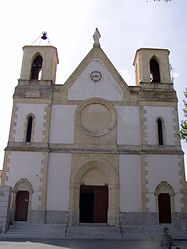
The church of Rousset
|
||
|
||
| Coordinates: 43°28′52″N 5°37′19″E / 43.481°N 5.622°ECoordinates: 43°28′52″N 5°37′19″E / 43.481°N 5.622°E | ||
| Country | France | |
| Region | Provence-Alpes-Côte d'Azur | |
| Department | Bouches-du-Rhône | |
| Arrondissement | Aix-en-Provence | |
| Canton | Trets | |
| Intercommunality | Aix-Marseille-Provence | |
| Government | ||
| • Mayor (2008–2014) | Jean-Louis Canal | |
| Area1 | 19.50 km2 (7.53 sq mi) | |
| Population (2008)2 | 4,290 | |
| • Density | 220/km2 (570/sq mi) | |
| Time zone | CET (UTC+1) | |
| • Summer (DST) | CEST (UTC+2) | |
| INSEE/Postal code | 13087 /13790 | |
| Elevation | 196–480 m (643–1,575 ft) (avg. 224 m or 735 ft) |
|
|
1 French Land Register data, which excludes lakes, ponds, glaciers > 1 km² (0.386 sq mi or 247 acres) and river estuaries. 2Population without double counting: residents of multiple communes (e.g., students and military personnel) only counted once. |
||
1 French Land Register data, which excludes lakes, ponds, glaciers > 1 km² (0.386 sq mi or 247 acres) and river estuaries.
Rousset is a commune in the Bouches-du-Rhône department in southern France close to Aix-en-Provence.
Although Rousset can be traced back to the Romans, the first written mention comes in a 1050 document, under the name of "Rosselun" or "roscetum rosetum". In the Middle Ages, a castle as well as a church and chapels were built, as dwellings increased.
In the 9th century, Rousset belonged to Saint-Victor, then by 1143 the Knights Templar took over, followed by the Knights of Malta in 1307. In the 15th century, it belonged to Guillaume de Littera (1371-1452).
Under the French Revolution, the castle was destroyed.
The church was built in 1861.
It is now home to a semiconductor fab and research center of STMicroelectronics and until 2014 also of another fab of LFoundry (originally set up by Atmel)
...
Wikipedia


